Dennis J. Blasko
©2024 Dennis J. Blasko
This report analyzes the People’s Liberation Army’s (PLA) border reinforcement operation throughout the Aksai Chin and adjacent areas from summer 2020 to early 2021. It is based largely on analysis of Google Earth imagery and provides a baseline for further analysis of the PLA deployment along the entire Line of Actual Control (LAC) in the Aksai Chin. Chinese Army units appear ready to remain in a defensive posture near the LAC the Aksai Chin indefinitely. This effort is the land domain equivalent of Chinese military maritime operations in the South China Sea and air and sea deterrent operations directed toward Taiwan.
Keywords: People’s Liberation Army, Line of Actual Control, Aksai Chin, India, Xinjiang Military District
The People’s Liberation Army’s (PLA) Western Theater Command (TC) is responsible for defending nearly half of China’s landmass, yet only about one quarter of the PLA Army (PLAA) is deployed in the region. Two group armies are stationed in its eastern provinces, while the Xinjiang and Tibet Military Districts (MD) are assigned an assortment of units unlike those found in any other provincial military district.
Following the deadly clash in June 2020 between Indian troops and Chinese border defense forces, units from the Xinjiang MD stepped up their reinforcement operations in support of the two border defense regiments posted along the Line of Actual Control (LAC) in the Aksai Chin. This region is known in India as eastern Ladakh and commonly referred to by the Chinese military media as the Karakoram plateau (喀喇昆仑高原). By the end of 2020, six months after the deadly incident between Chinese and Indian forces in the region, the PLAA had built fortified defensive positions along the LAC to support a reinforced combined arms division, some of which extended approximately 20 miles behind the LAC.
This operation, known as the “506 Special Mission,” involves rotational deployments of forces for training to the Sino-Indian border and began after a three-week incursion on the Depsang Plains by a PLAA platoon in 2013.1 Until a negotiated political settlement is reached, the Western TC is prepared to sustain the rotation of units into and out of the region in the largest near-combat deployment since the end of the border conflict with Vietnam in 1987.2 This operation is the land domain equivalent of the PLA Navy’s reef expansion construction in the South China Sea and deterrence operations conducted around Taiwan.3 In 2022, the US Department of Defense called the PLA’s actions in the Aksai Chin “a large-scale mobilization and deployment of PLA forces along the LAC” without providing further detail.4
This report begins with a brief description of the geography of the region, a review of the PLAA order of battle in the Western TC, and a short discussion of the normal posture of Chinese border defense units in the Aksai Chin. Then, based on analysis of (public access) Google Earth imagery from spring 2020 to January and February 2021, a sector-by-sector description of PLAA units deployed along the LAC and supporting units roughly 50 miles behind the LAC follows. More frequent, current, and better quality commercial imagery is available for organizations able to pay for access to it, such as governments, think tanks, and the media. Information from Chinese state television and military newspapers supplemented the Google Earth imagery to estimate, whenever possible, unit size, type, and identification. Consistent with its usual adherence to secrecy—and in contrast to frequent Indian media coverage—the official Chinese media (including PLA sources) have not provided specific details about the extent of the ground deployment of units involved in the standoff.5
The objective of this report is to provide a baseline for further analysis of the PLAA’s deployment as a whole along the entire LAC in the Aksai Chin and in adjacent support areas to the north and south. Except for limited coverage of four relatively small areas in October 2021 and August 2022, more recent Google Earth imagery of the five major deployment sectors where out-of-area combat units were deployed in 2020 is unavailable as of late February 2024. As additional imagery is made public, these initial assessments should be updated or corrected.
Background Geography
The Aksai Chin comprises the western sector of the 2,100-mile disputed Sino-Indian border defined by the LAC. As seen on figure 1, the road and railroad infrastructure in the region is extremely limited, as are the number of airfields. The distances between major cities are great, and transportation is difficult because of the altitude, mountains, rivers, deserts, and climate. The average elevation in the Aksai Chin is some 17,000 feet (over 5,000 meters) above sea level, requiring troops from lower elevations to take days to over a week to acclimate, and frequently requires the use of oxygen while marching or exercising. The altitude and extreme cold also adversely affect the performance of weapons, vehicles, and aircraft.6
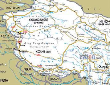
Figure 1. Road network into Aksai Chin
(Source: “China Map – Road Map of China,” Ezilon.com Regional Maps (website), 2009, https://www.ezilon.com/maps/asia/china-road-maps.html. Annotated by the author.)
Only one highway, China National Highway 219 (G219), connects Xinjiang to Tibet from Yecheng/Kargilik in southern Xinjiang through the Aksai Chin to Lhasa in the east. A second highway through the Aksai Chin, G695, was reported to be under construction in 2022, but no map of its route has been released.7 The road distance from Urumqi to Yecheng/Kargilik in south Xinjiang is almost 1,000 miles and then over 270 miles more via G219 to Kangxiwa (all distances are approximate, as measured by Google Maps or Google Earth for straight-line distances). A second road, G580, from Hotan to Kangxiwa (probably under 100 miles long) was reported open in late 2022.8 This road cuts many hours of driving time from Hotan to Kangxiwa and, perhaps more importantly, adds a second parallel route south from the railheads in southern Xinjiang. The closest railheads to the Aksai Chin are on the railroad circling the Takla Makan Desert at Hotan and Yecheng/Kargilik. The last portion of this line around the Takla Makan Desert from Hotan to Ruoqiang was completed in mid-2020.9
To the east of the Aksai Chin, the closest railhead in Tibet is at Xigazê, about 860 miles by G219 to Rutog at the eastern end of the Pangong Lake. Railheads in Lhasa are over 1,000 miles by road to Rutog. In addition to G219, a second road, S301, starts north of Lhasa and connects to Shiquanhe through the center of Tibet some 100 to 200 miles north of G219. Overland logistics support to Lhasa must travel nearly 1,200 miles from Xining, over 700 miles by road from Golmud, and over 1,200 miles from Chengdu. The most direct route from Xining to Hotan is about 1,500 miles.
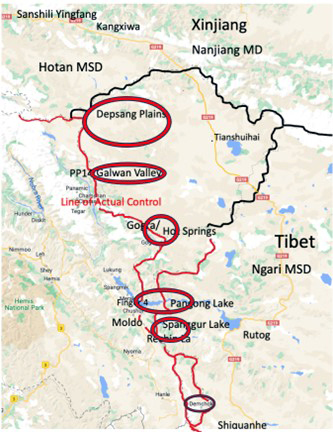
Figure 2. Map of the Aksai Chin
(Source: Google Maps as base, annotated by the author. The cities of Hotan and Yecheng/Kargilik are off the map to the north in south Xinjiang.)
As seen on figure 2, the western edge of the Aksai Chin stretches for roughly 250 miles along the LAC from the Karakoram Pass and Depsang Plains in the north to Demchok in the south. About 35 miles to the northwest from the northern boundary of the Aksai Chin, Kangxiwa—the site of a martyrs’ cemetery—is used as an Army training area.10 Moving south, the Galwan River Valley is approximately 30–35 miles beyond the southern edge of the Depsang Plains (straight-line distance), Gogra/Hot Springs is another 35 miles south, with the north shore of Pangong Lake 40 miles further south. Eight to 10 miles south of the Pangong is the Spanggur Lake, with the Spanggur Gap between the two bodies of water. The Indian camp at Chushul is about eight miles west of Moldo at the western end of the Spanggur Lake. During the 1962 Sino-Indian war, several battles were fought in these areas.
Highway G219 runs for about 112 miles near the eastern border of the region at a distance of some 60–70 difficult miles from the LAC. About six miles west of the Indian side of the LAC, the 160-mile Darbuk-Shyok-Daulat Beg Oldie (DSDBO) section of the road between the Karakoram Pass and Leh (about 50 miles northwest of Pangong Lake) was upgraded in 2019.11 Both China and India have been improving the road, rail, and air transportation infrastructure through this difficult terrain for many years, resulting in an infrastructure construction arms race. Most of the Aksai Chin, from the Depsang Plains in the north to Gogra/Hot Springs, is administered by Hotan county in Xinjiang. The area from Gogra/Hot Springs to the south is part of Ngari/Ali prefecture in the Tibet Autonomous Region. Even though the southern portion of the Aksai Chin is located in the western reaches of Tibet, the Nanjiang (south Xinjiang) Military District subordinate to the Xinjiang MD is responsible for military operations in the disputed area, including all of Ngari.
Subordinate to the Nanjiang MD, the Hotan Military Subdistrict (MSD) is responsible for border operations along the LAC in the north, while the Ngari MSD is responsible for border operations in the southern sectors of the Aksai Chin, which includes the Pangong and Spanggur lakes. The corps-grade Nanjiang MD commander (major-general rank) has been the principal PLA representative to a series of “high-level military talks” (21 meetings to date) between the two militaries to defuse the situation and separate their forces in close proximity to each other along the LAC.12 The Chinese Foreign Ministry and the Indian External Affairs Minister’s office conduct a separate political dialogue on the border issues, known as the Working Mechanism for Consultation and Coordination (WMCC) on China-India Border Affairs. Its 26th meeting was held in Beijing on February 23, 2023, and was the first in-person meeting since 2019 (no face-to-face meetings were held during the COVID-19 lockdown, even after the 2020 Galwan Valley clash).13
Western Theater Command Army Order of Battle
As seen on figure 3 below, the home garrison locations for Western TC Army units are widely dispersed throughout this mountainous and desert region approximately half the size of the continental United States. The theater’s northeastern region is dominated by the Gobi desert, while further west the Takla Makan Desert occupies the center of Xinjiang, with the Tibetan plateau and Himalaya and Karakoram mountain ranges bordering India, Nepal, and Bhutan to the south.
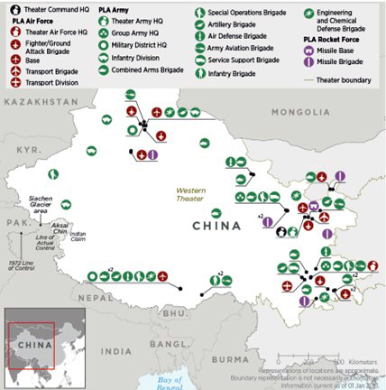
Figure 3. PLA unit locations in the Western Theater Command
(Source: Department of Defense [DoD], Military and Security Developments Involving the People’s Republic of China 2022, Annual Report to Congress [Washington, DC: DoD, November 2022], https://media.defense.gov/2022/Nov/29/2003122279/-1/-1/1/2022-MILITARY-AND-SECURITY-DEVELOPMENTS-INVOLVING-THE-PEOPLES-REPUBLIC-OF-CHINA.PDF)
Two group armies are assigned to the Western TC: the 76th Group Army headquartered in Xining, Qinghai, and the 77th Group Army headquartered in Chongzhou, near Chengdu, Sichuan—about 1,300 and 1,500 miles, respectively, from the LAC by straight-line distance measurement (much longer to travel by road). Each group army is assigned a total of 12 or 13 brigades (but no divisions): six combined armed brigades (either heavy, medium, or light, each with four combined arms battalions); plus six or seven support brigades, including an artillery brigade, air defense brigade, army aviation (helicopter) brigade, special operations forces (SOF) brigade, engineer and chemical defense brigade, and service support brigade.14 (The 77th Group Army has an engineer brigade and a separate chemical defense brigade, for a total of 13 brigades.)
No group armies are assigned to either the Xinjiang or Tibet MDs. Instead, the Xinjiang MD commands four combined arms divisions and other combat support units: in the south, the 4th Combined Arms Division in Kuqa and Aksu and the 6th Combined Arms Division in Hotan, Yecheng/Kargilik, and Kashi; and in the north, the 8th Combined Arms Division in Wusu, Shihezi, and Tacheng and the 11th Combined Arms Division in and near Urumqi.15 (The four divisions in Xinjiang were restructured and redesignated as combined arms divisions in late 2020 or early 2021.)
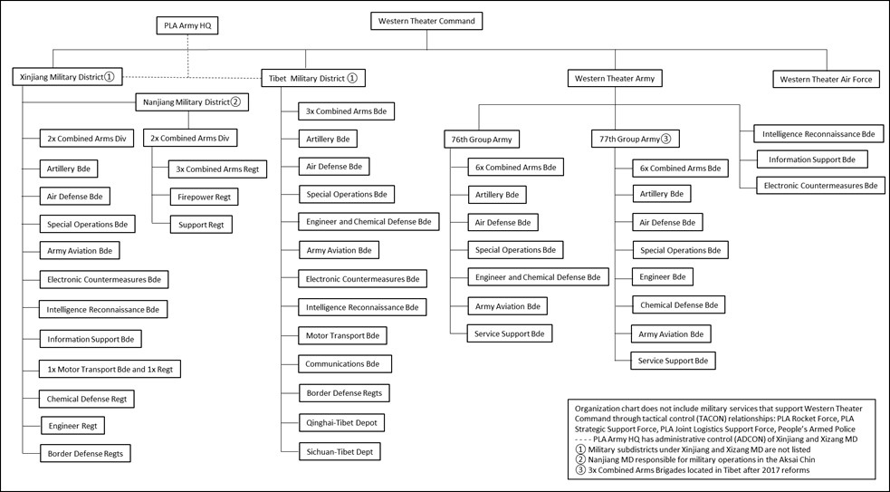
Figure 4. Combined Arms division organization
(Source: Created by author)
Each combined arms division commands a total of about 10,000 personnel organized into three combined arms regiments (each with three combined arms battalions, a firepower battalion, operational support battalion, and service support battalion), a firepower regiment (with artillery and air defense units), and support regiment.16 Xinjiang MD also commands an information support brigade, intelligence and reconnaissance brigade, artillery brigade, air defense brigade, army aviation brigade, SOF brigade, electronic countermeasures (ECM) brigade, engineer regiment, and a chemical defense regiment.17 A Western TC Army information support brigade and intelligence and reconnaissance brigade and additional communications and motor transport (truck) units also support operations in the region. These units vary in number of personnel from about 2,000 to 3,000, depending on the type.
On the other hand, the Tibet MD commands three combined arms brigades, an artillery brigade, an air defense brigade, an army aviation brigade, an SOF brigade, an ECM brigade, as well as an engineer, chemical defense brigade, communications brigade, and information support brigade, and intelligence and reconnaissance brigade, all of which are stationed near Lhasa or further to the south and east.18 One of its light (mountain) combined arms brigades was relocated from Nyingchi to Yadong, close to the site of the 2017 confrontation with Indian forces at Doklam, an area disputed with Bhutan.19 Additionally, three combined arms brigades from the 77th Group Army have been relocated to Tibet since 2017, while the rest of the group army is stationed to the east in Sichuan and Chongqing.20 The PLA categorizes the group armies, divisions, and brigades described in the paragraphs above as “mobile operational units,” which may be deployed away from their home garrisons.21
The Joint Logistic Support Force’s Xining Joint Logistics Support Center, the PLAA’s Qinghai-Tibet Army Depot headquartered in Golmud, and the Sichuan-Tibet Army Depot operating out of Chengdu provide logistics support to the entire region. While each TC has a Joint Logistic Support Center, the latter two depots are unique to the Western TC because of the region’s size, geography, limited (but growing) infrastructure, and dependence on road and rail transport.22
Approximately 15 PLAA border defense regiments, plus seven associated support battalions in Xinjiang and four production regiments in Tibet, are stationed throughout the Xinjiang and Tibet MDs. Unlike border and coastal defense brigades in the other TCs, these forces retain their pre-reform structure in regiments under the command of prefectural-level MSDs. The total number of Army personnel stationed in the entire Western TC is probably around 250,000, with about one-tenth of that figure (around 20,000) assessed to be deployed in and around the Aksai Chin at any one time.
PLAA Border Defense Posture in the Aksai Chin
Military operations in the Aksai Chin and on the surrounding Karakoram plateau are usually conducted by Army border defense regiments from the Hotan and Ngari MSDs, including a patrol boat squadron (battalion) on Pangong Lake subordinate to the Ngari MSD.23 As will be seen below, the exact size and structure of these and other border defense regiments likely vary according to mission requirements and terrain in their area of operations. Regiments are composed of an estimated five or six operational and support battalions, each with multiple 100-man companies. In general, border defense companies stationed on or near the LAC are armed mostly with light infantry weapons; a few armored personnel carriers (around a dozen) and mortars may be assigned to battalions located further away from the front.
Chinese media reporting prior to the June 2020 incident identified four border defense companies permanently deployed in fixed facilities subordinate to the Hotan Border Defense Regiment in the northern portion of the Aksai Chin from the relatively flat Depsang Plains down to the mountainous, highly channelized topography near Gogra/Hot Springs. The four companies were situated near the LAC at Shenxianwan/Immortal Bay and Tianwendian on the Depsang Plains, Heweitan north of the Galwan Valley, and at Gogra/Hot Springs to the south.24 Distances between these permanent facilities vary from roughly 10 miles to over 30 miles (straight-line distance). No company was stationed permanently in the Galwan Valley.
These units occupy traditional brick and mortar military barracks with a few associated support buildings, vehicle sheds, and other structures such as helicopter landing pads, communications towers, and firing ranges; often defensive fighting trenches are found in the adjacent hills (some of which sport political slogans on their slopes). Personnel assigned to these units man observation outposts and towers in their area of responsibility and conduct foot and vehicle patrols according to procedures agreed to by both the Chinese and Indian militaries. This deployment pattern suggests approximately one battalion of the regiment was stationed close to the LAC while the remaining two or three battalions were stationed further back, most likely at the Sanshili Yingfang barracks, headquarters of the Hotan MSD Border Defense Regiment, located outside the northern limit of the Aksai Chin (about 40 miles northwest of Kangxiwa).
The complex of military facilities at Sanshili Yingfang includes several barracks areas, training grounds (used to host out-of-area combat units on rotational training deployments), and a small helicopter airport with a short runway and 12 hangars.25 Elements of the battalions stationed there could patrol the gaps between the forward-deployed companies, reinforce specific areas as required, and act as a mobile reserve force. Companies from one of these battalions likely had been deployed temporarily to the Galwan Valley (probably to protect road construction work in progress) and were involved in the deadly clash on June 15, 2020. Sometime after the 2020 clash, two additional border defense companies subordinate to the Hotan Border Defense Regiment were established, one on the Depsang Plain and one in the Galwan Valley.
In contrast to the way companies from the Hotan Border Defense Regiment are deployed, analysis of the Ngari Border Defense Regiment in the southern portion of the Aksai Chin and further south reveals more than a dozen border defense companies and the patrol boat squadron stationed in permanent facilities on or near the LAC. These units are found along the north bank of Pangong Lake, on the south shore of the Spanggur Lake, south to Demchok, and outside the Aksai Chin in Ngari Prefecture. Several of these companies have outposts located on ridge lines near their barracks. The number of forward-deployed companies amounts to up to three battalions, likely leaving only about one battalion, plus the probable regimental headquarters and support units located in Shiquanhe (colocated with the Ngari MSD headquarters) about 65 miles south of the eastern end of the Pangong Lake. A small helicopter airfield exactly like the one found at Sanshili Yingfang, built around 2016, is also found in Shiquanhe, along with areas that appear to be used for military field training.26 One border defense battalion has also been identified south of the Aksai Chin in Zanda county.
As part of the 506 Special Mission, these border defense units have been augmented temporarily over the past decade by elements of the divisions and brigades assigned to the Xinjiang MD. Such deployments familiarize the out-of-area mobile operational units with the terrain and conditions near the LAC, giving them the chance to conduct training in an austere environment relatively close to a live potential enemy.
In the spring of 2020, PLAA border defense units and out-of-area combat units increased training and patrolling in the region and established new outposts along the LAC in the Galwan Valley, at Gogra/Hot Springs, and near Pangong Lake.27 Although provocative, these movements likely occurred within the limits of China’s territorial claims.28 In early May, Chinese and Indian soldiers engaged in a fistfight, which increased tensions along the LAC.29 On June 15, 2020, elements of a battalion of the Hotan Border Defense Regiment engaged in hand-to-hand combat with Indian forces in the Galwan River Valley at the confluence of the Shyok River near a location called Patrol Point 14 that resulted in the deaths of 20 Indian and four Chinese border defense soldiers. No shots were fired during the encounter.30 Reportedly, the Indian Army has established 65 Patrol Points from the Karakoram Pass to Chumur, an area outside the Aksai Chin, about 50 miles due west of Demchok.31 The exact locations for all Patrol Points have not been released publicly, yet much media reporting refers to activities at individual Patrol Points. Thus, the precise location of certain events is uncertain due to inconsistencies in reporting.32
At about the same time, at approximately 80 miles straight-line distance to the southeast, the Ngari Border Defense Regiment had set up an estimated company-size tent encampment on the LAC at Finger 4 on the north shore of Pangong Lake and established multiple dispersed platoon- and company-size outposts running north for at least three miles along the ridge line that defines the LAC (see figures 16 and 18).33 Additionally, out-of-area mobile operational units began to construct temporary camps in the valleys to the east along Pangong Lake. The June incident appears to have accelerated and may have expanded plans for PLAA deployments throughout the Aksai Chin. The initial reinforcing units came from the 6th Mechanized Division stationed in multiple garrisons in Nanjiang, the closest at least a 400-mile drive to the LAC along G219.34
The following section briefly assesses the situation in each of the sectors in the Aksai Chin in late 2020 or early 2021 based on Google Earth imagery. These images provide only a few snapshots in time; plus, units commonly move in and out of positions and improve or modify their encampments, so the situation on the ground is constantly changing. All deployment areas have undergone days or weeks of engineering work to build revetments and construct berms around tents and equipment. Along with an array of tents of varying sizes, prefabricated shelters and containers are visible in many deployment areas. In addition to the locations identified below, many other small camps and field positions have been constructed throughout the region—some empty, some partially occupied, and some apparently abandoned. Others are used by civilian construction companies building new roads and bridges throughout the region.
Sector-by-Sector Analysis of the PLA Development
Based on an analysis of limited Google Earth imagery between spring 2020 and early 2021, it appears the PLA moved the entire 6th Combined Arms Division (formerly Mechanized Division) to reinforce the two border defense regiments stationed in the region spread across four sectors: in the Galwan Valley, Gogra/Hot Springs, the north shore on Pangong Lake, and into the Spanggur Gap and along the south shore of the Spanggur Lake. Based on Chinese state television reportage, sometime in the spring or summer of 2021, the 11th Combined Arms Division traveled from Urumqi by road (or part of the way by rail to south Xinjiang) to relieve the 6th Combined Arms Division and assume responsibility for the border reinforcement mission.35 By October 2022, the 6th Combined Arms Division (having been upgraded with new equipment, including Type 15 light tanks) is assessed to have begun to return to “the front” in the Aksai Chin and continued to be deployed near the LAC through the summer of 2023.36 By late summer 2023, elements of the 8th Combined Arms Division appear to have been deployed to the Aksai Chin to relieve the 6th.37 Over time, these divisions have been reinforced and supported by a variety of elements from other units in the Xinjiang MD and Western TC. To date, no mobile operational units assigned to the Tibet MD have been identified operating in the Aksai Chin.
Any movement of out-of-area units into (or out of) the Aksai Chin region requires a complex transportation plan due to the distances involved, limited infrastructure, harsh terrain, climate, altitude, and the need to acclimate soldiers to the thin air. Depending on a unit’s point of origin and type of equipment, deployment to the vicinity of LAC would require multiple days, at a minimum, to several weeks for larger units from greater distances. While railroads could be used for the initial delivery of personnel and equipment to southern Xinjiang, road movements must be staged in daily segments for the last several hundred miles and are probably conducted in battalion-size increments. Wheeled vehicles may drive for long distances over roads, though whenever possible they would be transported by rail to prevent wear and tear. Tracked armored vehicles and large engineering equipment need to be transported long distances on roads by heavy equipment transporters (HETs) to the front. Civilian tractor trailers probably provide additional support to these movements.
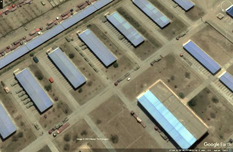
Figure 5. Type 15 light tanks load on HETs in 6th Combined Arms Division barracks in Yecheng/Kargilik in April 2022 prior to the unit’s return to the Aksai Chin
(Source: Google Earth/Maxar Technologies)
Because military convoys travel at slower speeds than civilian traffic, multiple rest and refueling areas must be established along the route. Before moving to the LAC, final assembly areas were prepared to the north of the Aksai Chin in and around Sanshili Yingfang and Kangxiwa, and at Rutog and Shiquanhe to the south.38 Larger units would assemble at these locations, acclimatize, rest and refit, and prepare for the final movement to their frontline positions. Units assembled around Kangxiwa would likely occupy the Galwan Valley, Gogra/Hot Springs, and perhaps Pangong Lake sectors while units would travel to Rutog to deploy to the Spanggur Lake sector. At the same time, units that have spent months near the LAC would be preparing to return to their garrisons and would probably use the same HETs that had delivered fresh forces to return home. Old and new units probably overlap as one leaves and another takes its place, resulting in a temporary spike in the total number of personnel present in the region above the estimate of 20,000 assessed above.
While at the front, units receive new soldiers and equipment and conduct both political and military training—including live fire drills—similar to that which is conducted at or near their home bases. Because of the extended period for which units are deployed, a large infrastructure has been constructed to augment the normal headquarters compounds, fighting positions, sleeping and dining facilities, and logistics areas usually established to support a unit in the field. Large numbers of prefabricated shelters and containers have been used to create living areas, military and political training venues, complete medical facilities (including dentists, psychological counseling, and altitude acclimation units), shower and washing areas, vehicle maintenance and repair shops, storage areas (for seasonal uniforms and equipment not currently in use), and small shops so that soldiers may purchase uniforms and small personal comfort items. As a result, the footprint of unit deployment areas is extremely large and visible, as tents and prefabricated shelters in barren areas are covered with camouflage nets or tarps (many of which are rose-colored) and surrounded by earthen berms. The fortified field camps are constantly being improved and expanded (and vacated) as units arrive, encamp, and leave. Such camps require tremendous amounts of engineering and construction support, which must also be trucked in from hundreds of miles away.
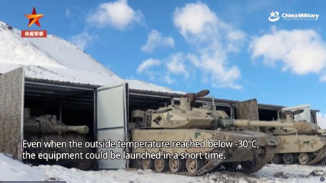
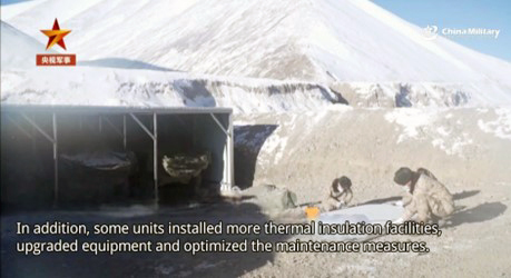
Figure 6. Screenshots of vehicle shelters in Aksai Chin, January 2023
(Source: “Combat-readiness Support Capability in Winter Plateau Greatly Improved,” China Military Online (website), January 5, 2023, http://eng.chinamil.com.cn/MEDIA/Videos/10209897.html)
The following estimates of the size and types of units deployed have been determined by the number and types of equipment observed (armored vehicles, artillery, trucks, and so forth), deployment patterns, the number of tents and prefabricated shelters, vehicle shelters, and fortified emplacements, and the size of the area in which they are deployed. This analysis is not an exact science, but the extended deployments in the Aksai Chin look very different from the patterns seen when units travel to major training areas such as the Zhurihe Training Base or Dacheng Bay amphibious training area.
Depsang Plains (reinforced border defense units, air defense site)
No Google Earth imagery was available for most of the Depsang Plains from the spring of 2020 to early 2021 during the major influx of troops into the region. A portion of the plains was imaged in August 2022, centering on the Tianwendian border defense company, and shows at least six relatively new camps constructed within a six-mile radius of the company’s permanent barracks.39 A new compound composed of prefabricated shelters, vehicle sheds, and solar panels had been erected immediately adjacent to the preexisting company barracks. The layout and vehicles present suggest the company had been reinforced with units from the border defense regiment at Sanshili Yingfang. Less than one mile northeast of the facility, a site capable of supporting an air defense battalion had also been built. This position, however, is likely occupied by elements from the Xinjiang MD air defense brigade or a combined arms division firepower regiment.
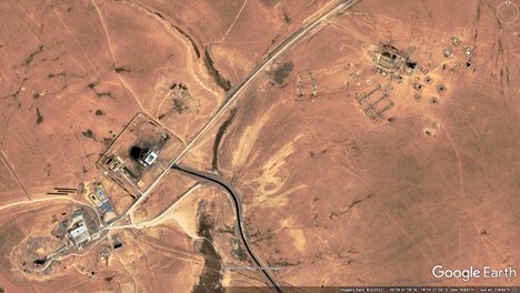
Figure 7. Tianwendian border defense company on Depsang Plains (lower left), expanded area (center), air defense site (upper right), August 2022
(Source: Google Earth/Maxar Technologies)
In addition, the new Binglianshan/Snow Lotus Mountain Border Defense Company southeast of Tianwendian was reported being formed in September 2021.40
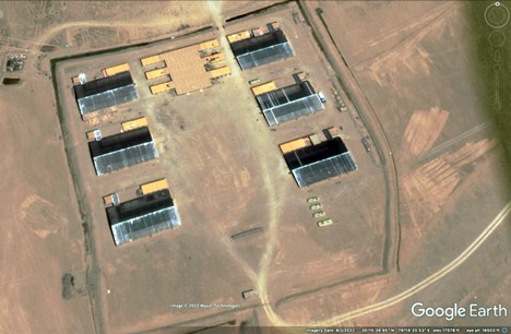
Figure 8. Likely new border defense company at Binglianshan/Snow Lotus Mountain, composed primarily of prefabricated shelters, August 2022
(Source: Google Earth/Maxar Technologies)
At least three other widely scattered camps, built mostly with prefabricated shelters, plus one training area with tents, could probably support a full battalion of border defense troops. Several sets of unoccupied trenches and firing positions are visible throughout the imaged area.
Galwan Valley (combined arms regiment, new border defense company)
About two miles up the valley from the site of the June 2020 incident, a new permanent, company-size multistory border defense barracks was built on the north (sunny) side of the valley, with electricity provided by a solar array on top of the southern ridge by January 2021.41 Prior to spring 2020, no border defense unit was permanently stationed at this location, but patrols would be dispatched to the area to conduct reconnaissance and surveillance. At the time of the June 15 incident near Patrol Point 14, a temporary tent camp with more than 100 vehicles had been observed at this location.42
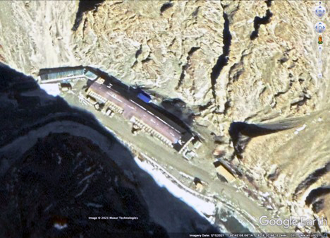
Figure 9. Permanent border defense barracks built in Galwan Valley after the June 2020 incident, January 2021
(Source: Google Earth/Maxar Technologies)
In early 2023, Chinese television reported on a Galwan border defense company located on a mesa above the valley that occupied a newly built camp composed primarily of prefabricated shelters for troops and vehicles.43 The main mission of this recently formed company would be to observe and patrol the valley and surrounding mountains up to the LAC on a routine basis (not intermittently, as was likely the case prior to June 2020). No recent Google Earth imagery has been acquired to identify the exact location of this new company, however, and the current status of the barracks built in 2020 is unknown.
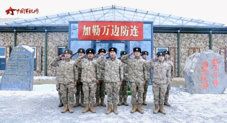
Figure 10. Screenshot of new Galwan border defense company, composed primarily of prefabricated shelters for troops and vehicles located on a mesa, January 2023
(Source: “Military Report,” China Central Television-7 [website], January 19, 2023, https://tv.cctv.com/2023/01/19/VIDEwHuwvFHihY2e4KWe9HVf230119.shtml?spm=C28340.P3GbPoIN6ktz.Ei1cdgvmaht5.18)
By October 2020, approximately 23 miles up the Galwan Valley from the LAC, a large field camp for out-of-area combat troops had been built in the valley floor and on surrounding mesas stretching for three miles. It appeared to accommodate multiple battalions of a combined arms regiment, with armored vehicles, trucks, tents, and storage containers concealed by camouflage netting or canvas coverings extending over the length of the encampment. Artillery firing positions had been prepared on the valley floor. At the far eastern end of the camp, a support unit with mobile bridges, engineer equipment, and mobile hospital tents was present.44 Although high up the Galwan Valley, this site is located only about seven miles via the road north of Patrol Point 15 at Jianan Daban on the LAC as the line traverses from the northwest to southeast, roughly parallel to the course of the Galwan.
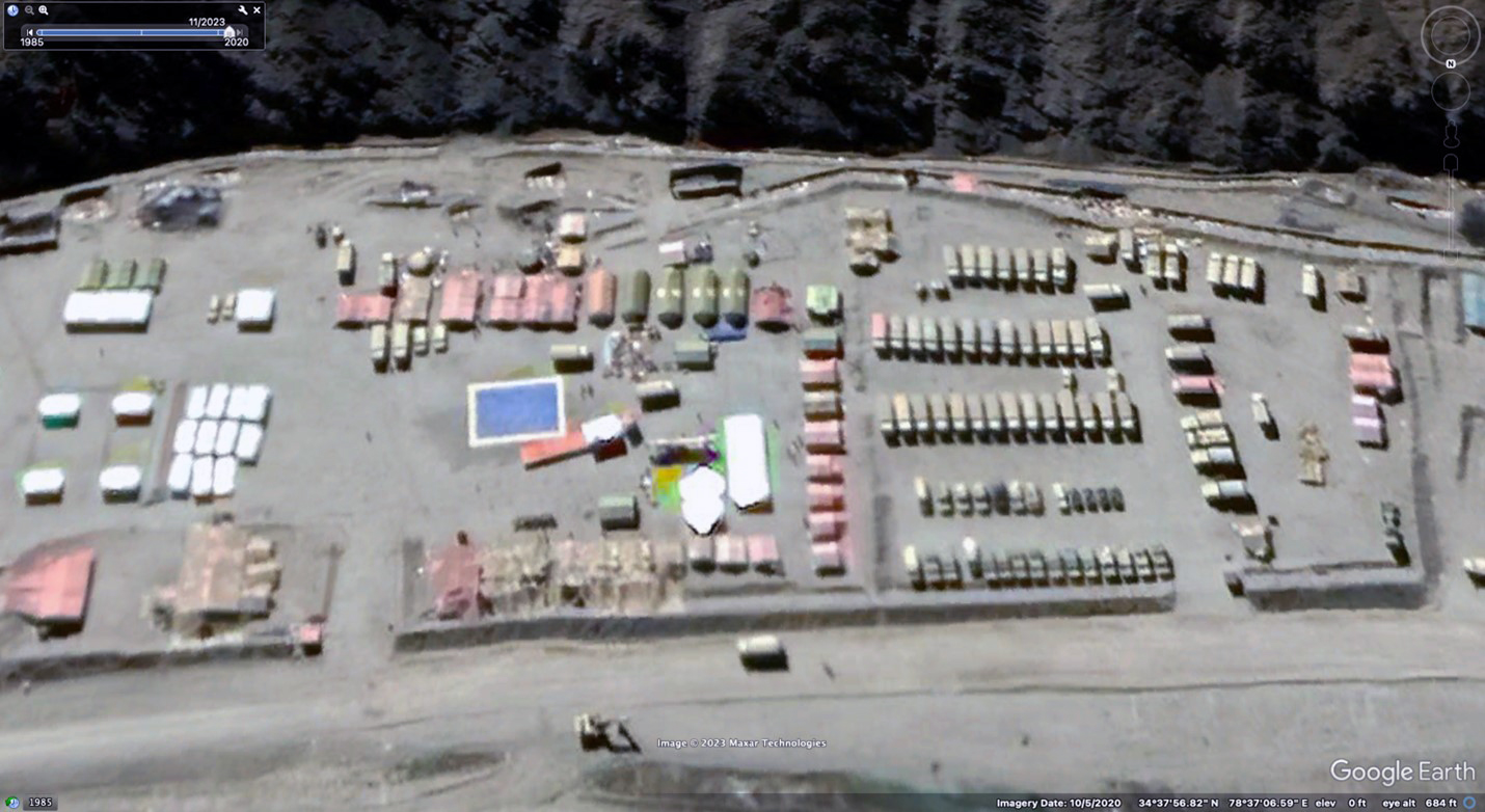
Figure 11. Support area for combined arms regiment in Galwan Valley, October 2020 (note the three green field hospital tents center frame)
(Source: Google Earth/Maxar Technologies)
Gogra/Hot Springs (combined arms battalion, air defense unit, reinforced border defense units)
This deployment area is approximately equidistant from the regiment in the Galwan Valley and the forces on the north shore of Pangong Lake. Due to its central location, it is possible that the previously existing Gogra Pass (Kongka-La) border defense company facility (with a communications tower and three helicopter pads) behind a hill with the Chinese characters “能打仗打胜仗” (Be Able to Fight and Win) was being used as a headquarters for operations in the region.45 In the valley floor just south of the facility, a field air defense site was built and occupied during the summer of 2020. Entrenched positions in the valley extending over a mile to the south from the border defense facility appeared to be minimally occupied.
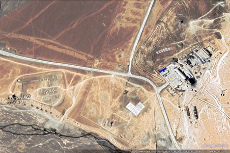
Figure 12. Gogra Pass border defense company (right) and air defense site (left), October 2020
(Source: Google Earth/Maxar Technologies)
At the same time, in another valley two and a half miles to the northeast, an estimated combined arms battalion had established itself in a field camp with tents, trenches, and revetments at the base of a ridge extending for a mile to the north.46 Sixteen drive-through covered fighting positions for armored vehicles sufficient to accommodate a company-size unit were visible on the valley floor oriented to the west in the direction of the LAC.
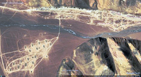
Figure 13. Infantry battalion encampment and company fighting positions northeast of Gogra Pass border defense company, October 2020
(Source: Google Earth/Maxar Technologies)
Approximately 13 miles northwest of the Gogra Pass border defense facility in a valley running north from the LAC, a series of six field camps was observed in imagery from January 2021 to September 2022. The first camp is located about a mile north of the LAC along a paved two-lane road and is composed of numerous prefabricated shelters and buildings with defensive fighting trenches on an adjacent hill.47 The layout and vehicles outside the structures suggest this to be a border defense facility built recently (no structures were visible in December 2018 imagery). A second similar compound is about half a mile to the north, with the others another three miles away and further to the rear. Throughout this deployment area, which perhaps accommodates a border defense battalion, many earthen revetments have been constructed to protect structures and vehicles.
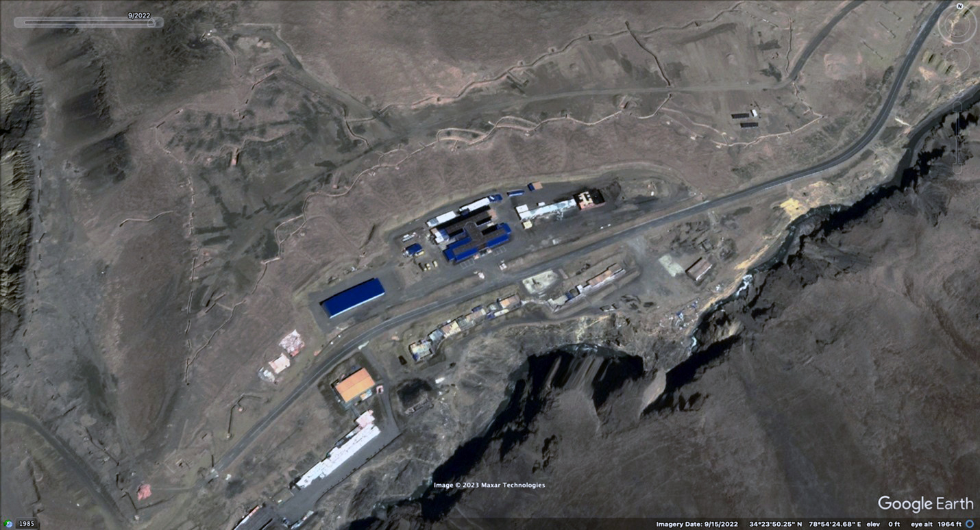
Figure 14. Recently constructed prefabricated facility for likely border defense unit about a mile north of the LAC, northwest of Gogra Pass, September 2022
(Source: Google Earth/Maxar Technologies)
On September 8, 2022, the Indian Ministry of External Affairs announced that “the Indian and Chinese troops in the area of Gogra-Hotsprings (PP-15) have begun to disengage in a coordinated and planned way” but provided no further details about the exact location of the withdrawal of the forces involved.48 A week after that announcement, Google Earth imagery nevertheless showed the camp closest to the LAC (described in the paragraph above) to be active and intact.49 Over a year later, the Chinese Defense Ministry spokesman stated the situation on the LAC was stable and that the two militaries had disengaged at four points in the Galwan Valley, Pangong Lake, Hot Springs, and Jianan Daban.50
North Shore of Pangong Lake (combined arms regiment and firepower regiment, border defense unit)
The ridges closest to the LAC on the north shore of Pangong Lake are numbered from west to east as Finger 1 to Finger 8, with Finger 4 defining the LAC itself.51 (At least four maps with differing locations of the eight fingers have been published in the Indian media.) The Chinese-controlled area, Fingers 4 through 8 with the Sirijap Plan to the east, are shown in figure 15.
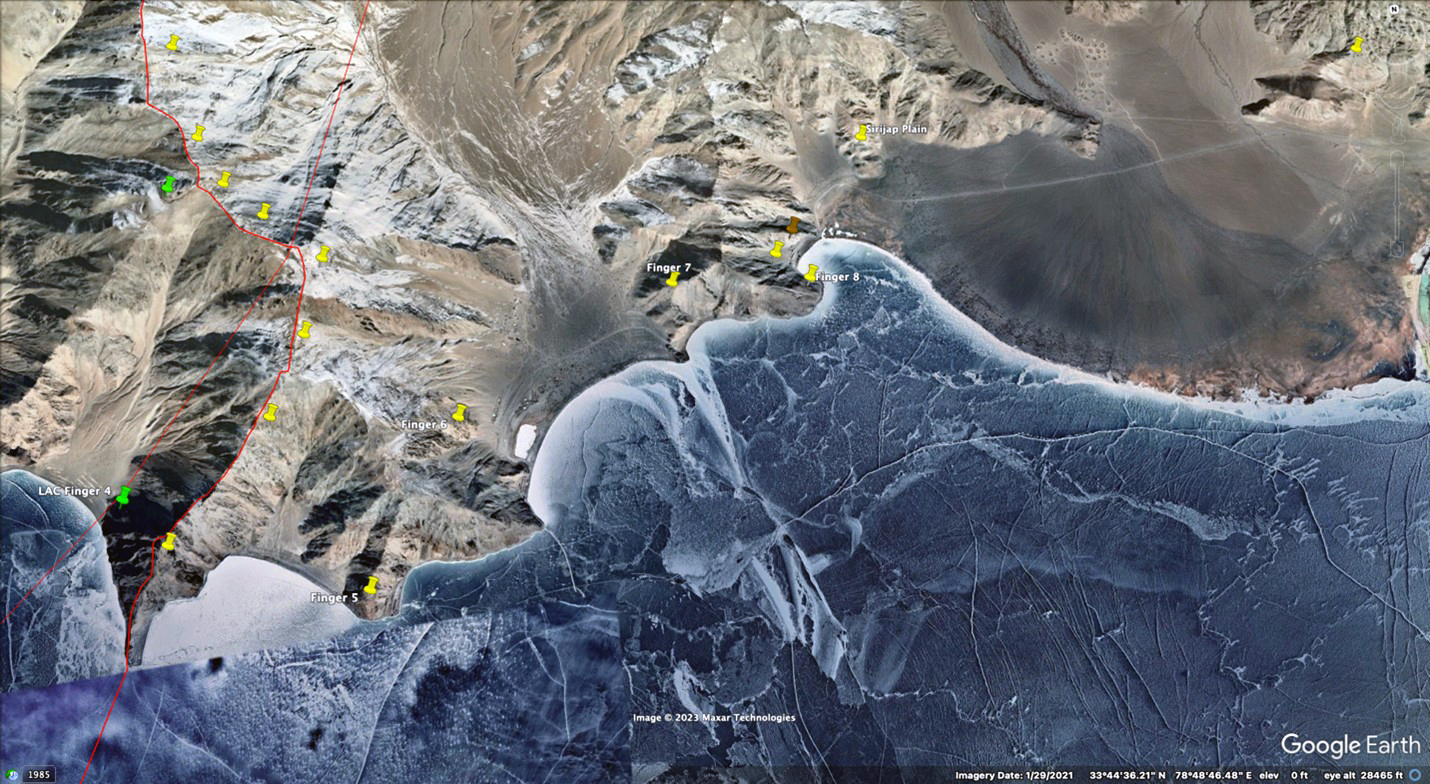
Figure 15. Fingers 4–8 on north shore of Pangong Lake with the Sirijap Plain to east, January 2021
(Source: Google Earth/Maxar Technologies)
Prior to the June 2020 incident in Galwan, Indian forces were deployed to the west of Finger 4, while Chinese units had begun building field positions to the east. By June 2020, the PLAA had established a small, probably company-size outpost on the east side of the base of Finger 4. Indian positions were located to the west on the reverse side of the ridge less than a mile away (at the green pin on figure 15), but the units were not in direct line of sight of each other.52
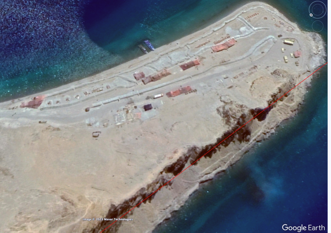
Figure 16. Probable PLA company outpost under red camouflage tarps on LAC (red line) at Finger 4 on north shore of Pangong Lake (note two patrol boats on the shore), June 2020
(Source: Google Earth/Maxar Technologies)
After negotiations following the June 2020 incident, the PLAA’s most forward position at Finger 4 on the LAC (figure 16) was vacated, and by January 2021, a new position of similar size was visible a mile to the east behind Finger 5 (figure 17).53
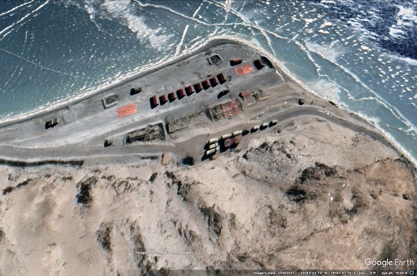
Figure 17. After negotiated withdrawal, probable PLA company outpost at Finger 5 on north shore of Pangong Lake, January 2021
(Source: Google Earth/Maxar Technologies)
While the PLAA position on the shore at Finger 4 was withdrawn, multiple Chinese outposts (generally company-size or smaller) were observed on the LAC extending north along the ridge for five miles (probably amounting to a battalion-size deployment) through the end of January 2021.54 One such outpost is seen in figure 18.
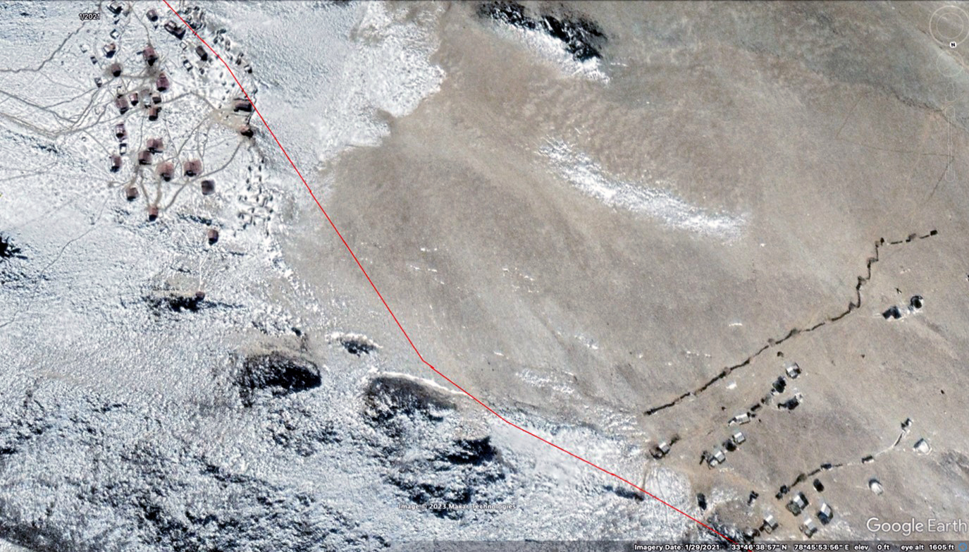
Figure 18. PLA outpost (upper left) 300 meters from Indian Outpost (lower right) on LAC (red line) on Finger 4 on north shore of Pangong Lake, January 2021 (after withdrawal along shore)
(Source: Google Earth/Maxar Technologies)
Over the months from June 2020 to January 2021, the PLAA units expanded their field camps and fighting positions in every valley for 18 miles to the east of the LAC and occupied them with elements of a combined arms regiment and a firepower regiment (with artillery and air defense weapons). Figure 19 shows a typical camp with fortified living quarters, storage facilities, parking areas, and defensive trenches. These encampments were supported by existing border defense facilities and units, including the three small dock facilities for the patrol boat squadron subordinate to the border defense regiment under the Ngari MSD. The squadron has a small forward floating dock with prefabricated shelters at Finger 8 at the west end of the Sirijap Plain (identified by the brown pin on figure 15), a second dock three miles to the east adjacent to a radar facility near a hill with a map of China and patriotic slogans, and headquarters and a concrete pier 18 miles east of the LAC at Rimuchang (figure 22).55
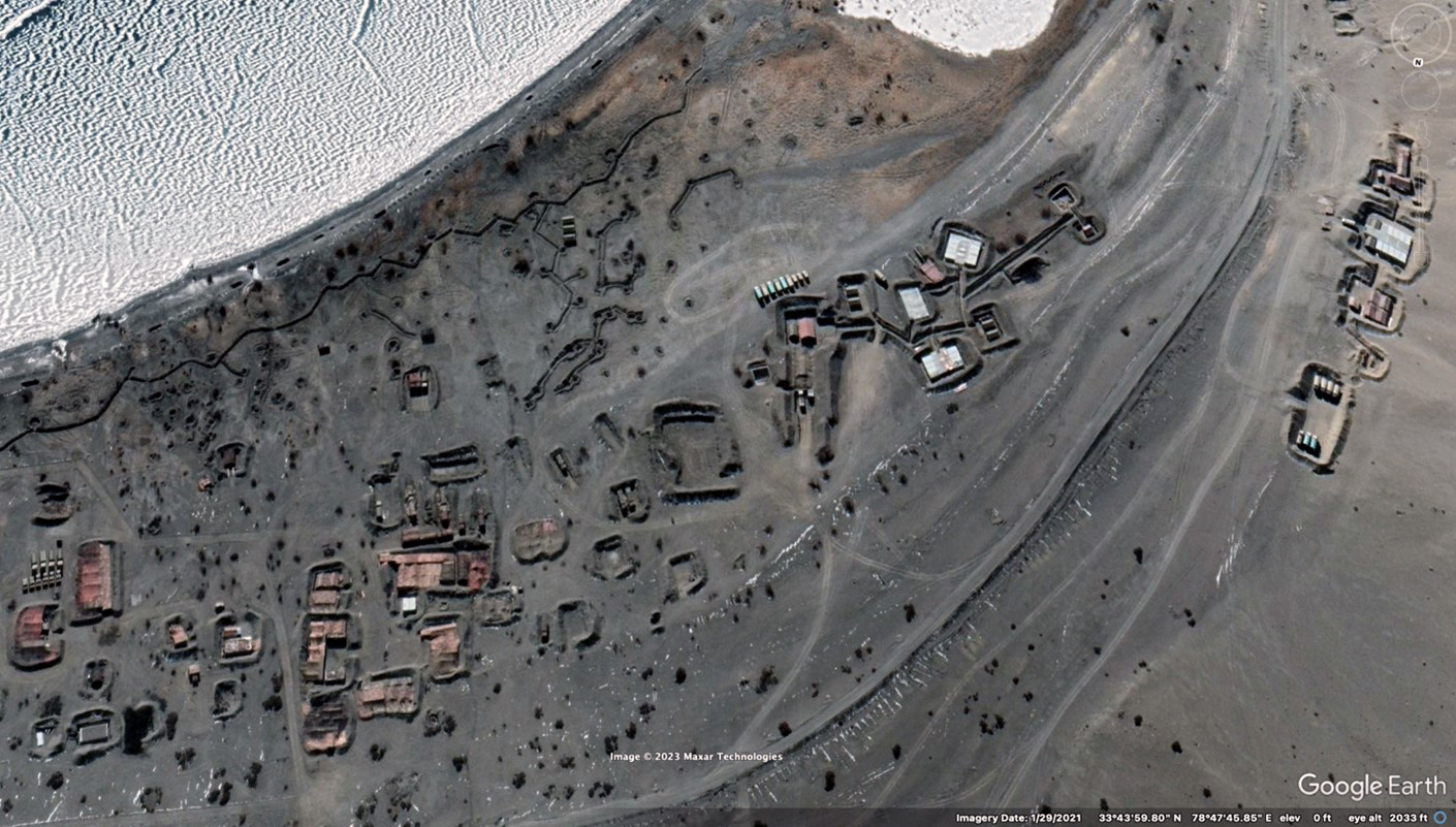
Figure 19. Fortified camp for elements of Combined Arms Regiment on north shore of Pangong Lake, January 2021
(Source: Google Earth/Maxar Technologies)
About one mile to the rear of Finger 5, starting at Finger 6, what appears to be at least one to two combined arms battalions had been established in a half mile–long position along the beach and inland extending back to the next ridge, Finger 7.56 Following further negotiations, these forward positions were reported to have been dismantled by mid-February 2021, but PLA positions were to be permitted east of Finger 8.57 The latest Google Earth imagery of the north bank of the Pangong Lake is from January 29, 2021, and, thus, the current status of PLAA deployments to the east of Finger 8 on the Sirijap Plain and further east cannot be determined by the means available for this report.
Prior to these negotiations, as seen in figure 20, about one mile inland from the shore along the western edge of the Sirijap Plain, a likely self-propelled artillery or 122mm multiple rocket launcher battalion was deployed in drive-through revetments oriented to the south (toward the Spanggur Gap) behind a low ridge.58 The type of weapons present was concealed by rectangular rose-colored tarps over the revetments. At the base of another ridge one mile to the east at the far edge of the Sirijap, elements of a towed 122mm howitzer battalion were deployed in circular firing positions connected by trenches.59
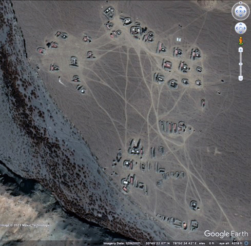
Figure 20. Fortified positions for elements of self-propelled artillery or multiple rocket launcher battalion on Sirijap Plain, north shore of Pangong Lake, January 2021
(Source: Google Earth/Maxar Technologies)
In November 2022, the Center for Strategic and International Studies (CSIS) reported that “what appear to be new division-level headquarters and garrison” had been built next to a ridge between the locations of these two artillery battalions.60 The CSIS article, however, did not report on the status of any other units in the area that could help substantiate whether the new field camp was a division headquarters or another type of unit—however, the imagery accompanying the article showed the likely self-propelled artillery or multiple rocket launcher battalion present in early 2021 (figure 20) had been relocated. The CSIS report is an example of how units move in and out of forward deployment areas and build new ones. In the time between early 2021 and late 2022, the 6th Combined Arms Division had been relieved by the 11th Combined Arms Division and then returned once more to the Aksai Chin. With every rotation of units into the region, changes to previous deployment patterns are to be expected.
In January 2021, in the next valley a mile to the east of the Sirijap Plain, another possible towed artillery battalion was encamped along the base of the ridge with two rows of tarp-covered firing positions in the valley floor.61 To its rear, another three miles beyond an intervening ridge, as seen in figure 21, a battalion of towed 152mm howitzers was deployed in dugout positions near the shore and inland at the base of a ridge.62 The number and type of artillery battalions deployed in this sector indicate a divisional firepower regiment.
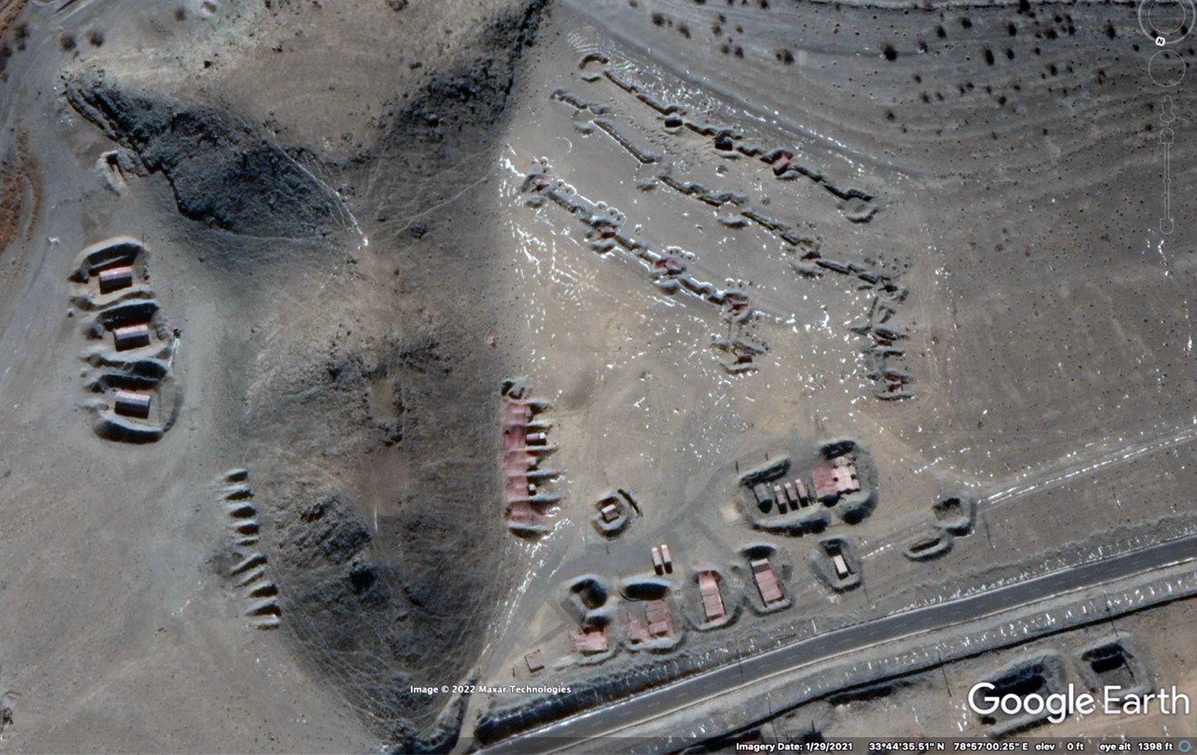
Figure 21. Firing positions for elements of 152mm artillery battalion on north shore of Pangong Lake, January 2021
(Source: Google Earth/Maxar Technologies)
Three miles further to the rear, to the east of a permanent border defense facility at Khurnak Fort, a square-shaped air defense position (with berms) was built in the summer of 2020, supported by a second position another two-and-a-half miles east.63 The permanent headquarters of the patrol boat squadron is another mile-and-a-half along the north shore at Rimuchang, ending what can be seen of the PLA deployment on the north shore of the Pangong Lake as of early 2021.
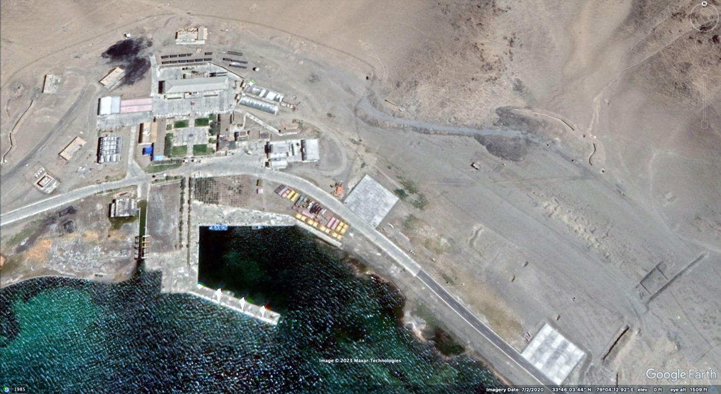
Figure 22. PLA Patrol Boat Squadron Headquarters at Rimuchang, Pangong Lake, July 2020
(Source: Google Earth/Maxar Technologies)
In early 2022, two bridges were reported to be under construction between Khurnak Fort and Rimuchang across the narrowest portion of Pangong Lake. A road on the south side of the lake is also being built to link the bridges with the existing road network to the south in the Spanggur Gap.64 When the bridges and road are completed, vehicular traffic will not need to go all the way to Rutog in order to reach the Spanggur Lake sector, significantly reducing travel time between units on the LAC.
Spanggur Gap and south shore of Spanggur Lake (combined arms regiment and support regiment)
Google Earth imagery is limited for the south side of Pangong Lake to the north shore of Spanggur Lake. As of January 25, 2021, about seven miles south of Pangong Lake (and about two miles north of Spanggur Lake) in the Spanggur Gap, what appears to be a combined arms or artillery battalion was spread out in three separate camps in the valley floor, with some 40 revetments and fighting positions visible.65
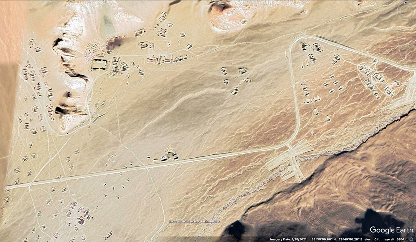
Figure 23. PLA positions in Spanggur Gap (only partial coverage of area available), January 2021
(Source: Google Earth/Maxar Technologies)
Further south along the south shore of Spanggur Lake, a permanent border defense company facility is located at the west tip of the lake at Moldo.66 Just over a mile to the east on the lake shore, by February 10, 2021, as seen in figure 24, a previously existing firing range had been fortified with bunkers and trenches and was being used as a supply base.67 Across the road inland was a fortified encampment with revetments protecting tents and prefabricated shelters and containers. Although two rows of trenches had been dug, no combat vehicles were observed, and approximately 30 trucks were in the area, including 14 lining up for a convoy on the road. This area appears to accommodate major portions of a support regiment.
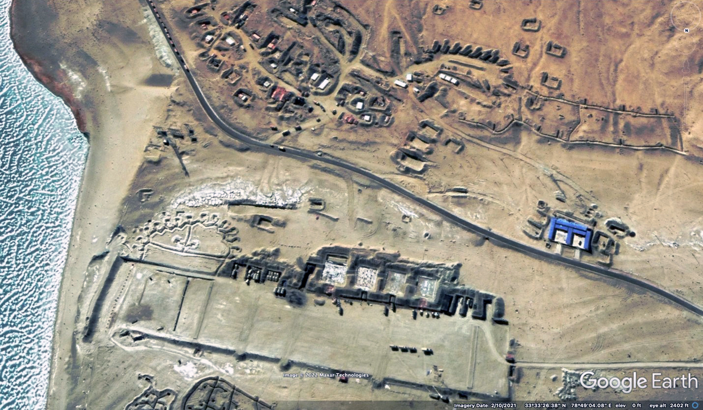
Figure 24. South bank of Spanggur Lake, support area built on Moldo border defense company firing range, February 2021
(Source: Google Earth/Maxar Technologies)
In early 2021, in the first valley two miles east of the firing range and supply depot (left side of figure 25), an air defense unit with at least two batteries of towed antiaircraft guns in firing positions near the shore provided protection for a fortified camp of tents in berms and vehicle revetments extending a mile inland to a trench line across the valley. (This camp could be the living quarters for personnel who work in the nearby supply depot.)68 In a second valley another mile east (right side of figure 25), an estimated combined arms battalion was encamped in fortified positions on both sides of the valley running about two miles inland (south) toward the LAC to a trench line with outposts on the flanks. A battery of towed 122mm howitzers in firing positions was deployed in the center of the valley oriented south toward the LAC.69 These two valleys lead to an area known as Rechin La (or Rezang La) on the LAC, approximately six miles inland from the lake shore.
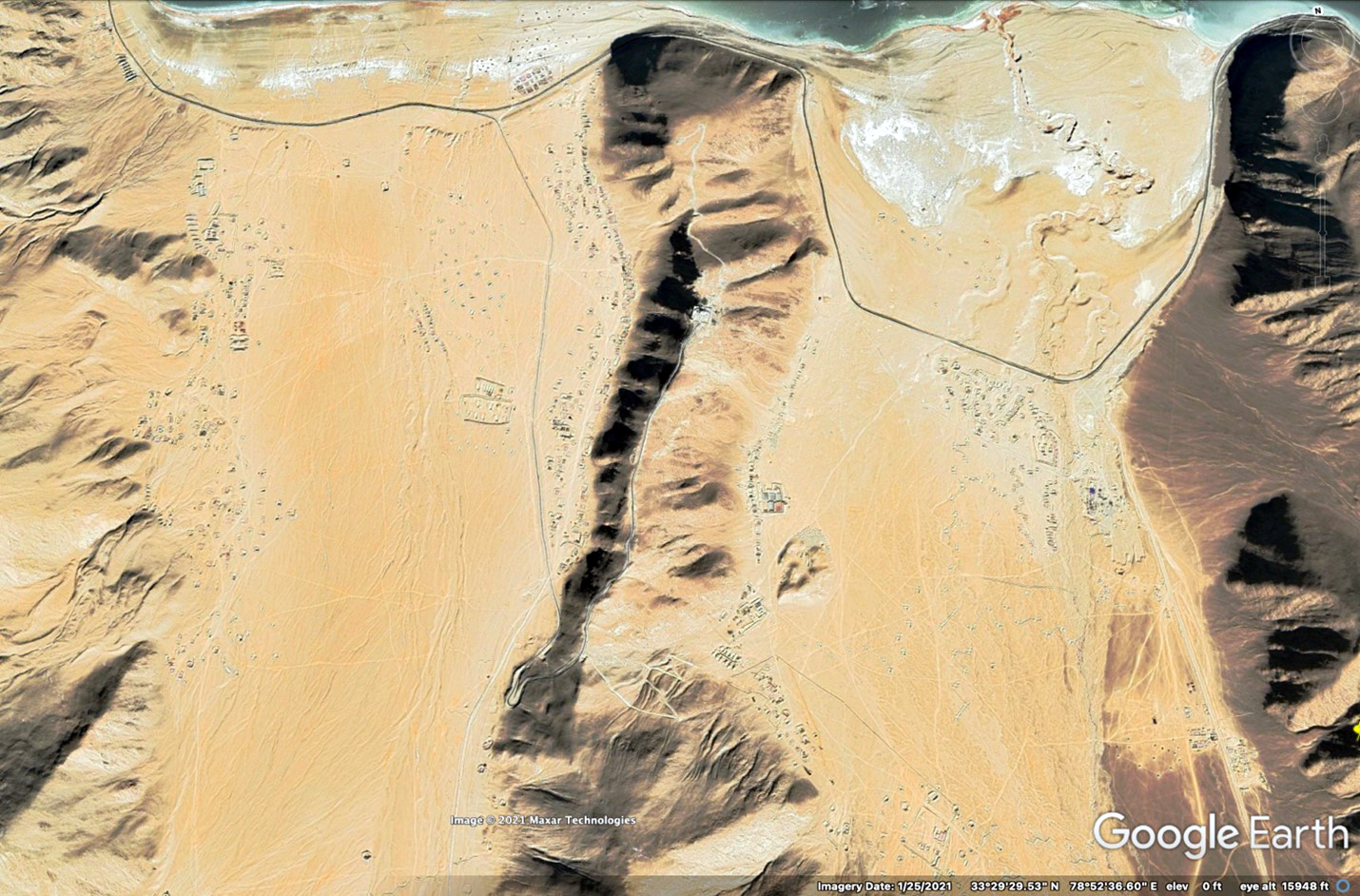
Figure 25. South bank of Spanggur Lake, fortified encampments for multiple battalions in Two Valleys leading to Rechin La, January 2021
(Source: Google Earth/Maxar Technologies)
As seen in the close-ups in figure 26, a small, rectangular permanent outpost subordinate to the Moldo border defense company is located at the top of the ridge between these two valleys. Throughout the region, elements of the two border defense regiments permanently assigned to the region are interspersed with and work closely with mobile operational units that rotate to “the front.”
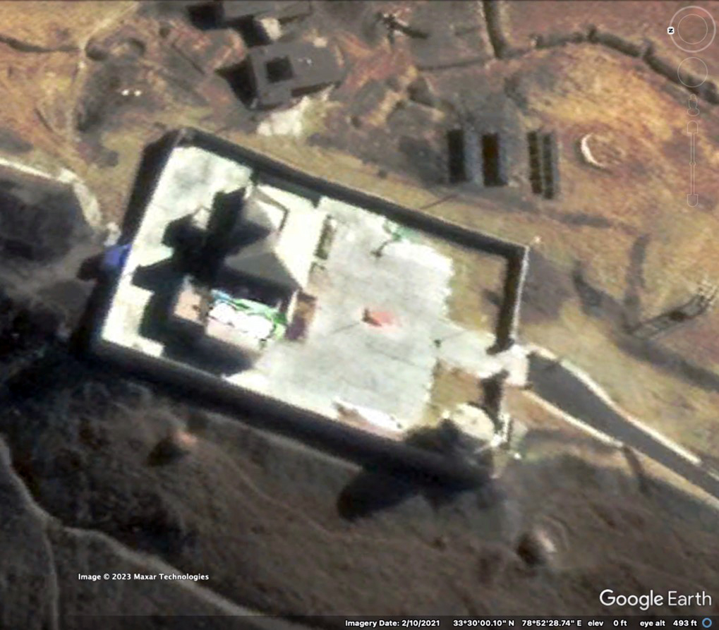
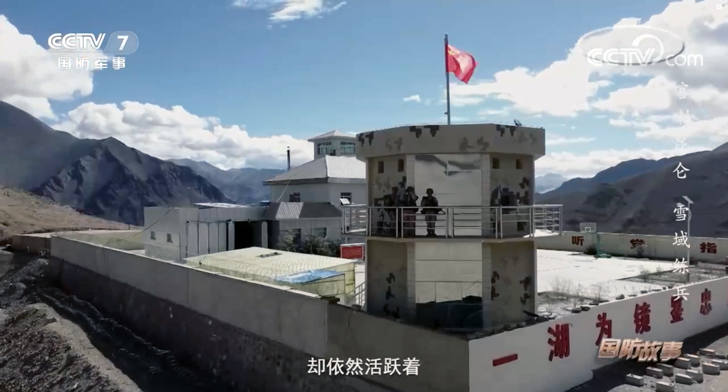
Figure 26. Moldo border defense company outpost on ridge south of Spanggur Lake (note the tower in lower right corner of the compound in Google Earth image is the same as the one in the screenshot), Google Earth image February 2021 and Chinese Central Television (CCTV) screenshot December 2022
(Sources: Google Earth/Maxar Technologies and CCTV-7 National Defense Story)
In the third valley, another probable combined arms battalion was settled on both sides of the ridges. About a mile inland from the shore of the lake, a series of infantry trenches and fighting positions stretch for over a mile to the south up the valley. On the eastern side of the third valley, about 1.3 miles south of the lake, two large overhead cranes were erected to load and unload large containers and other cargo from trucks.70 A half mile further up the valley, on January 25, 2021, a company of 16 canvas-covered armored vehicles was deployed in a combat formation oriented up the valley toward Rechin La conducting training during their tour on the plateau (figure 27).71
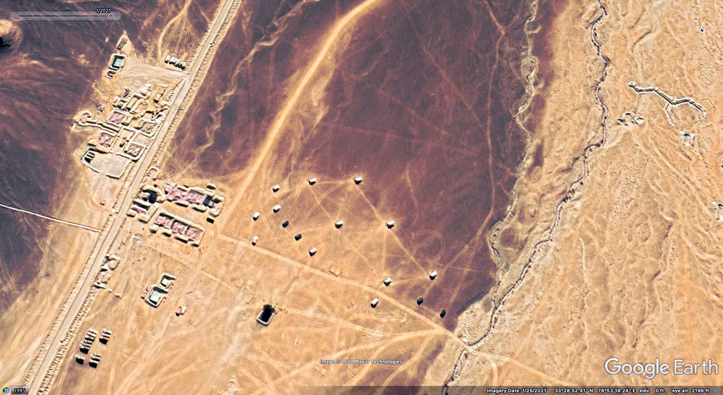
Figure 27. Company fighting formation of armored vehicles south of Spanggur Lake in front of its fortified field camp (note trenches dug in valley floor on right), January 2021
(Source: Google Earth/Maxar Technologies)
Three miles to the west in the fourth valley, another camp for an estimated combined arms battalion had established fighting positions, trenches, and vehicle revetments on both sides extending a mile and a half inland.72 Another estimated battalion-size element was located in a fifth valley about three and half miles to the east. What appears to be a company-size outpost protects the valley from the southern approach about two miles inland from the shore road.73
The last valley on the south side of the lake was a holding area for about 50 HETs in two groups (figure 28), one scattered under rose-colored camouflage covers in the center of the valley and another near the road parked side by side in two lines (a few more HETs were observed in other areas south of the lake on the same image). Nearly 70 unoccupied vehicle revetments had been dug on the eastern side of the valley. This area was likely an offloading point and assembly point for heavy equipment being moved into and out of the area.74 Lastly, at the northeast corner of Spanggur Lake, what appears to be an ammunition storage area with 22 revetments in a rectangular compound surrounded by a berm was established about 500 yards inland from fighting positions and tents in revetments near the road.75
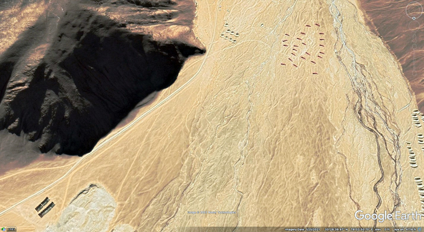
Figure 28. Approximately 50 heavy equipment transporters parked in valley south of Spanggur Lake (in two groups, top right and lower left), January 2021
(Source: Google Earth/Maxar Technologies)
In January and February 2021, several outposts near the LAC were observed in Google Earth imagery at Rechin La about six miles up the second and third valleys to the south of Spanggur Lake in close proximity (100–1,000 yards) to forward Indian positions. Three or four estimated company-size PLA positions with tanks and armored vehicles were spread out on ridge lines and reverse slopes for roughly a mile and a half along a road that zigzags near the LAC.76 One of those units, seen in figure 29, equipped with Type 99A tanks and ZBD-04 infantry fighting vehicles (indicating subordination to the 76th Group Army), was shown on Chinese television receiving gifts delivered by trucks from a Xinjiang MD Motor Transport Regiment during Chinese New Year 2021.77 The terrain, roads, and layout of tents on the side of the ridge visible in the televised report correspond with an outpost on the LAC at Rechin La seen in Google Earth imagery of January 25, 2021, and found at figure 30.78
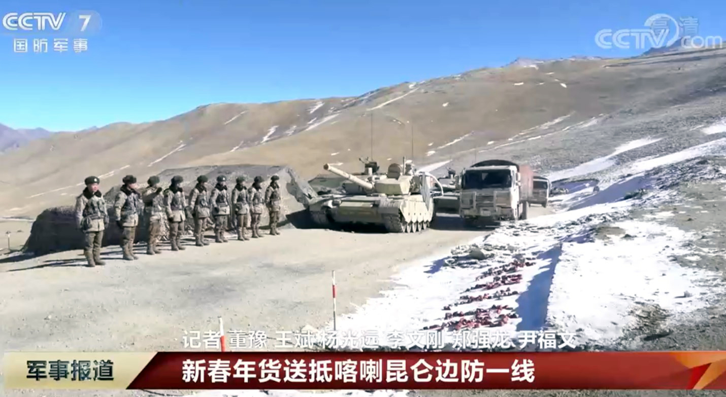
Figure 29. Screenshot of PLA outpost with Type 99 tank likely at Rechin La receiving New Year’s gifts, February 2021
(Source: CCTV-7 Military Report)
At the same time, Chinese and Indian corps commanders were discussing the repositioning of forces along the LAC, coming to an agreement which was implemented approximately two weeks later.79 The success of these negotiations was illustrated by a photograph in the Indian newspaper, The Print, on February 12, 2021, that showed at least five tanks and five other armored vehicles “pulling back from Rechin La on the southern side of Pangong Tso” on February 10.80 Based on Google Earth imagery from that date (figure 30), the tents remained in place, but no armored vehicles were observed. Chinese media would later report that the “two sides positively appraised the smooth completion of disengagement of frontline troops in the Bangong [Pangong] Lake area, noting that it was a significant step forward that provided a good basis for resolution of other remaining issues along the LAC in [the] Western Sector” but provided no exact details about the location, units involved, or where they moved to.81
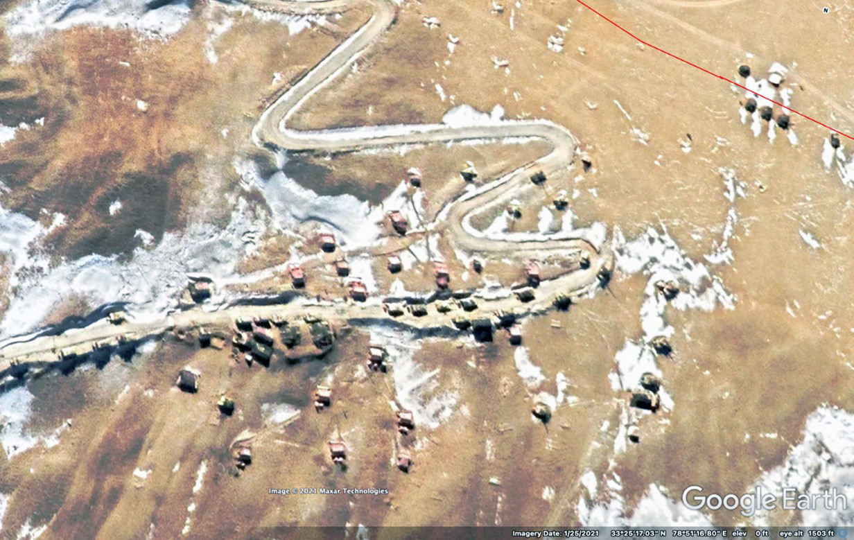
Figure 30. PLA outpost on LAC at Rechin La before negotiated withdrawal (note armored vehicles and trucks on road in front of tents on hillside); Indian position (upper right) January 2021
(Source: Google Earth/Maxar Technologies)
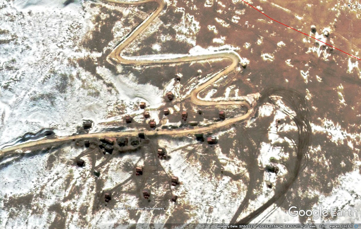
Figure 31. PLA outpost on LAC at Rechin La after negotiated withdrawal (note armored vehicles have left, one truck is visible, tents remain; new tank tread marks on ground), February 2021
(Source: Google Earth/Maxar Technologies)
Access to sectors on the Pangong and Spanggur lakes runs from China National Highway 219 through the assembly and transit point at Rutog, south of the eastern end of Pangong Lake. A likely deployment of elements of a battalion of PHL-03 long-range multiple launch rocket systems appears in imagery of Rutog from October 2021.82
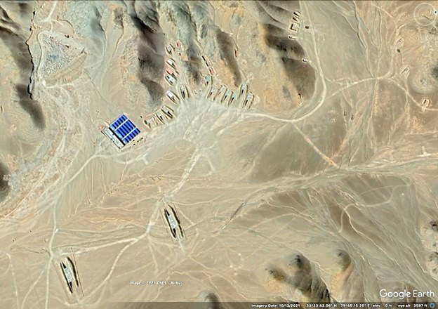
Figure 32. Likely PHL-03 long-range multiple launch rocket position near Rutog, October 2021
(Source: Google Earth/CNES/Airbus)
Two drive-through, camouflage-covered revetments for large vehicles (such as a PHL-03 launch vehicle) are situated on the reverse slope of protective hills, oriented toward the LAC to the west. Additional covered revetments for the remainder of the unit, probably including additional launchers, reload vehicles, and ammunition trucks, are dug into the sides of the nearby hill. This disposition suggests that one or two rocket launchers were on constant alert status, ready to provide immediate fire support to the southern half of the PLA’s frontage along the LAC in the Aksai Chin. Should the need arise, additional launchers could move from their sheltered positions to predesignated firing positions to provide support to front-line units. Otherwise, elements of the unit not on alert are free to perform routine training and maintenance.
A new assembly area east of Rutog town now appears to be used instead of an older one closer to the southeast of the town.83 A permanent depot for fuel trucks and heavy equipment transport vehicles is located at the western edge of Rutog, and what is likely a temporary vehicle maintenance facility has been set up about half a mile to the east.84 Of late, a heliport has been reported to be under construction about 50 miles northeast of Rutog near G219, along with other heliports further to the east in Tibet at Gerze, Nyima, and Seni.85 These four heliports are located almost in a line running east-west about 120 miles north of Lhasa at a distance of roughly 200 miles from one to another, allowing for them to be used for staged deployments or operations in the Aksai Chin.
Within the Aksai Chin itself, Google Earth imagery from January 2021 revealed another new helicopter airfield with 18 hangars under construction about 70 miles from the LAC near the town of Tianshuihai just west of the Aksai Chin Lake adjacent to G219; subsequent coverage in September 2022 indicated construction was still underway.86 Janes Defence Weekly further identified an air defense electronic warfare unit present at the airfield (the triangular configuration of small circles in the lower right of figure 33).87 This is the closest airfield to the LAC in the Aksai Chin and is likely operational by now. It can probably support and shelter up to 36 helicopters and potentially unmanned aerial vehicles (UAVs).
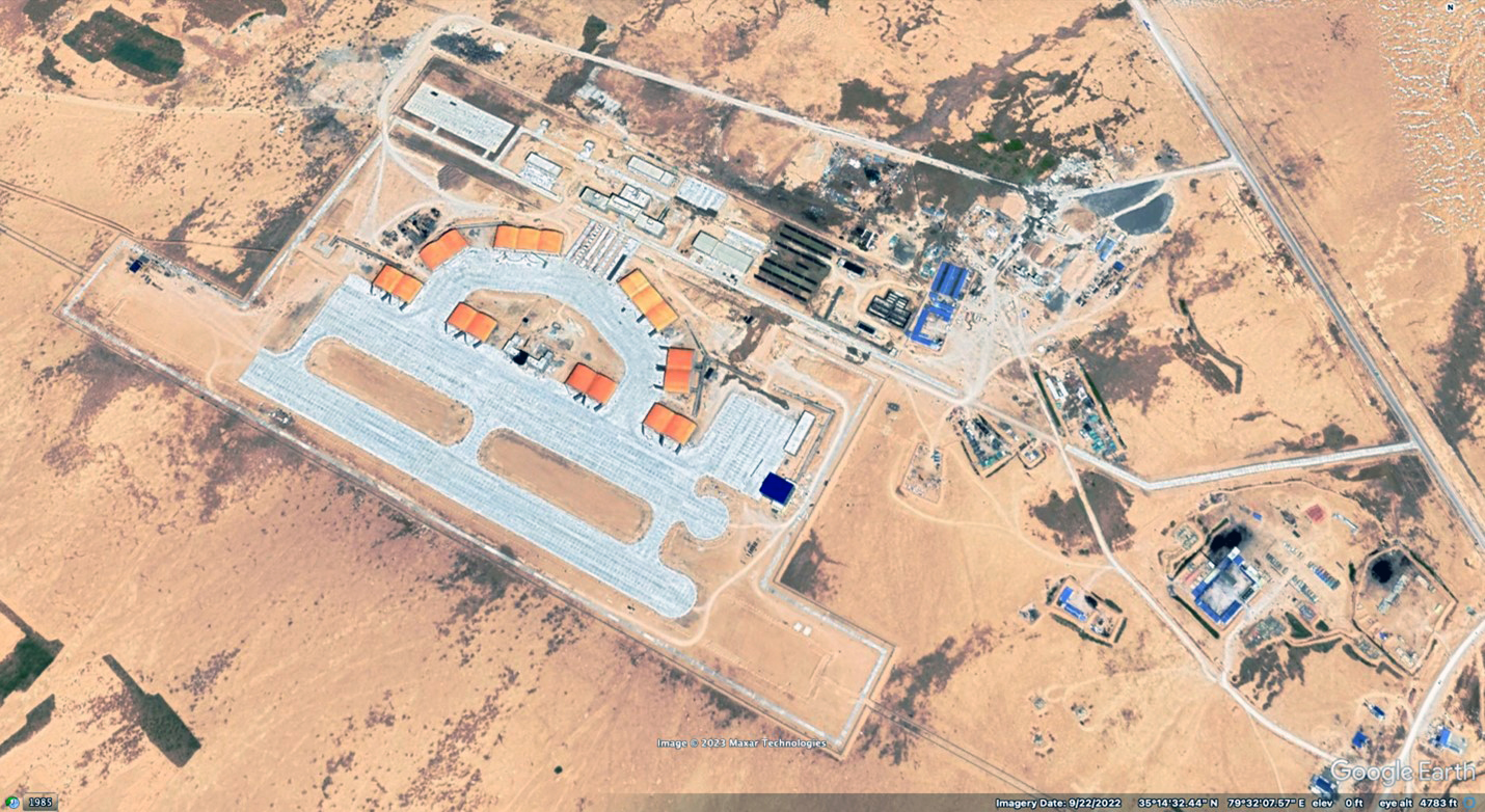
Figure 33. Airfield at Tianshuihai under construction, September 2022
(Source: Google Earth/Maxar Technologies)
In addition to the Xinjiang MD artillery brigade that commands the PHL-03 long-range multiple launch rocket systems likely seen at Rutog, elements from the MD’s air defense brigade, SOF brigade, engineering, communications, and transportation units, as well as units from other parts of the Western TC, have also been deployed to the Karakoram.88 For example, in the spring and summer of 2022, Chinese state television showed Z-10 attack helicopters and Mi-17 transport helicopters operating in the region flying out of the small heliport at Shiquanhe (see figure 34).89 In December 2022, the Chinese military media reported PLA Army CH-4 UAV training in the Karakoram.90
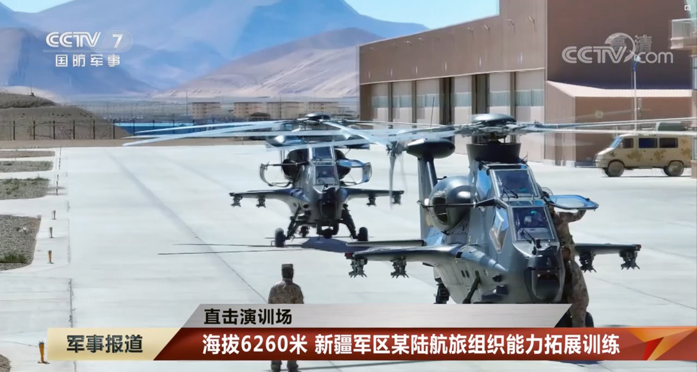
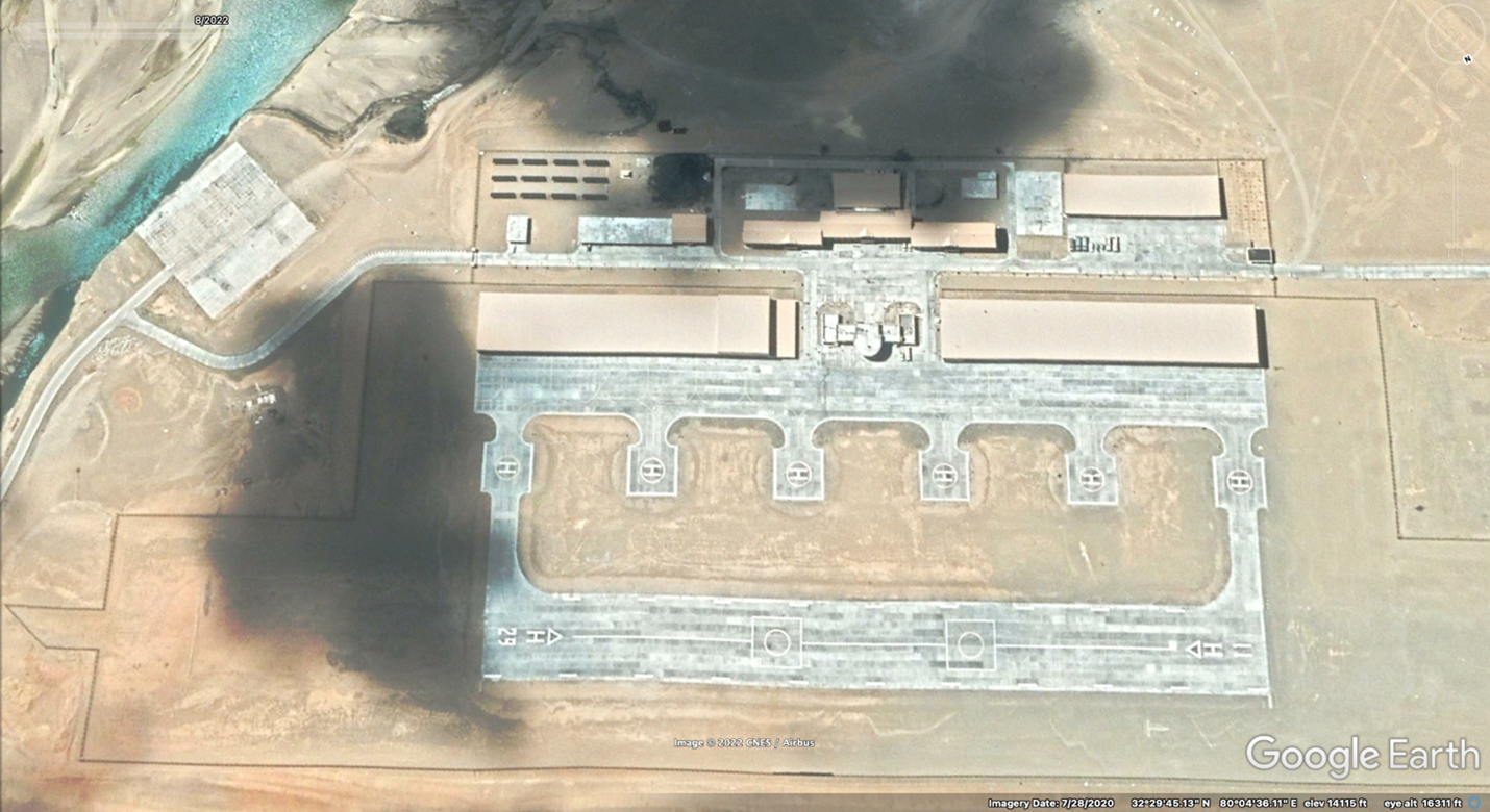
Figure 34. Z-10 Attack helicopters operating out of an airfield at Shiquanhe, CCTV screenshot July 2022 and Google Earth image July 2020 (note helicopters are located on the apron in front of the control tower between the two hangars)
(Source: Google Earth/Maxar Technologies and CCTV-7 National Military Report)
Finally, at the southern-most tip of the Aksai Chin, Google Earth imagery from August 2022 showed no significant change or reinforcement at a border defense facility near Demchok compared to imagery from 2020 except for a few new vehicle sheds that had been built.91
Conclusion
The most recent Google Earth coverage of the Aksai China has been limited to only a few small areas in the Depsang Plains, near Gogra/Hot Springs, and at Demchok in 2022. Therefore, without more current imagery available for this study, the current disposition of PLA units in the Aksai Chin is uncertain. (As mentioned earlier, other sources of commercial imagery are available to governments and the media.) Nonetheless, imagery available from late 2020 and early 2021 is sufficient to establish a baseline for where out-of-area PLAA units were deployed to reinforce border defense units throughout the entire region.
Although China’s state media continues to report on units on the “front line” (一线) or in “battle positions” (战位) in the Karakoram region (without specifying the Aksai Chin), it has done so without revealing the total number of troops deployed or their exact locations. Based on analysis of the open-source information described above, enough fortified positions were constructed in the various PLA-controlled sectors since the spring of 2020 to support a full division-size deployment—or roughly 10,000 personnel—on top of the two border defense regiments (approximately 5,000 personnel) already assigned to the region. Further, these units are reinforced by engineer, artillery, and support elements (probably numbering several thousand more personnel).
In total, roughly 20,000 PLAA soldiers are assessed to be deployed over the 250-mile front in the Aksai Chin along the LAC reaching back to distances of over 20 miles. This number may be higher during the period in which an out-of-area unit that has spent time on the LAC rotates out and is replaced by a fresh unit entering the area. Nonetheless, the 20,000 figure is a considerably smaller estimate of PLA personnel deployed in the disputed region than the 40,000–60,000 frequently asserted in non-Chinese media.92 Moreover, the estimated 20,000 personnel scattered across such a broad front is inadequate to conduct a large-scale offensive across the difficult terrain delineated by the LAC. Major offensive operations would require a significant buildup of units and supplies in order to reach to any substantial depth beyond the LAC. Instead, PLA units have been positioned to consolidate and hold territory, to conduct patrols and protect construction projects, and to create “facts on the ground,” similar to the reef expansion operations in the South China Sea a decade ago.93 The PLA is prepared to stay in the region for as long as it takes for the two governments to negotiate a solution.
The Aksai Chin does not favor large-scale armored or mechanized combat due to the channelization caused by steep mountains that limit or prohibit lateral movement. Similarly, both the altitude and extreme cold also reduce the effectiveness of mechanized and helicopter operations. As a result, because of the terrain, units are positioned throughout the region on much wider or narrower frontages than specified in PLA doctrine (see table 1 below).94
Table 1. Offensive and defensive frontages and depths in mountainous regions
| Unit |
Division |
Regiment |
Battalion Estimate |
| Defensive Front |
15–20 kilometers
10–12 miles |
6–9 kilometers
4–5 miles |
3–4 kilometers
2–3 miles |
| Defensive Depth |
20–30 kilometers
12–20 miles |
9–12 kilometers
4–7 miles |
4–6 kilometers
2–4 miles |
| Offensive Front |
5–8 kilometers
3–5 miles |
2.5–4 kilometers
1.5–2 miles |
1–2 kilometers
0.5–1 miles |
| Offensive Depth |
4–8 kilometers
2–5 miles |
1–2 kilometers
0.5–1 miles |
0.5–1 kilometers
< 1 mile |
For example, in 2020, the frontage of the PLA division deployed was roughly 100 miles wide (straight-line distance) from the Galwan Valley to Rechin La, multiple times the doctrinal width for either defensive or offensive operations. At the same time, the combined arms regiment deployed to the Galwan sector was in a valley less than a quarter of a mile wide, far narrower than prescribed by doctrine, and separated by more than 30 miles from the nearest combat unit.
The two combined arms regiments in the south were deployed over a 25-mile front along the LAC separated by two large bodies of water, the Pangong and Spanggur lakes, preventing mutual support by land maneuver—once more, a less than optimal disposition. Only the units in these southern sectors could provide each other with mutual support by organic indirect tube artillery and 122mm multiple rocket fire. Reinforcing long-range multiple launch rocket units stationed in and around Rutog and likely north of the Aksai Chin (perhaps near Kangxiwa), however, could cover the entire front with their fires. Similar deployments of air defense missile systems also provide some protection against aircraft flying above the mountain peaks.
Open-source reporting has provided only minimal clues about how PLA units prepare, assemble, and travel to and from their homebases to the front in the Karakoram along the LAC. The processes by which units deploy to and redeploy from the region and then are sustained from depots over a thousand miles away are topics worthy of detailed study.
A similar but much smaller situation has developed further to the east on the border at Doklam since the confrontation in the summer of 2017. Based on my analysis of Google Earth imagery, the Tibet MD light combined arms brigade located in Yadong County has established protected positions to reinforce border defense units stationed along the border with Bhutan. But likely only one reinforced combined arms battalion at a time of the combined arms brigade is deployed on about a one-mile-wide front at Doklam to a depth of about three miles. Forward deployed units are supported by the brigade’s artillery battalion operating from newly built hillside bunkers to the rear. In contrast to the situation at Doklam involving a combined arms brigade, however, initial reports of the Tawang border clash in December 2022 sound similar to the 2020 Galwan incident in which local border defense units made contact with Indian forces, not more heavily armed mobile operational units.95 No recent Google Earth imagery of the Tawang area is available to confirm this assessment, however.
Barring negotiations with the Indian military and government to withdraw out-of-area combat troops, the PLA appears ready to maintain its deployments near the LAC in the Aksai Chin and on the border at Doklam indefinitely. In the case of the Aksai Chin, due to the challenges of transporting large mechanized units over long distances, rotations of units into and out of the region will likely occur after an prolonged tour of duty (perhaps six months to a year or more). The situation has taken the form of PLA border operations against Vietnam following the 1979 war until 1987, albeit with fewer troops and less actual combat and artillery bombardment. The PLAA’s extended border reinforcement operations serve both political and military purposes and provide the units and staffs in the Western TC with real-world operational and logistics experience that cannot be achieved through routine peacetime training.
Dennis J. Blasko
Dennis J. Blasko (lieutenant colonel, US Army, retired) is a former military intelligence officer and foreign area officer specializing in China. He is an independent analyst and author of The Chinese Army Today (Routledge, 2012).
Endnotes
Author’s Note: This report updates a paper presented in October 2022 at the United States Institute of Peace - S. Rajaratnam School of International Studies “Lessons and Legacies of the Sino-Indian War” workshop in Singapore.
- Roderick Lee and Marcus Clay, “Commentary – Don’t Call It a Gray Zone: China’s Use-of-Force Spectrum,” War on the Rocks (website), May 9, 2022, https://warontherocks.com/2022/05/dont-call-it-a-gray-zone-chinas-use-of-force-spectrum/; and Manoj Joshi, “Depsang Incursion: Decoding the Chinese Signal,” Observer Research Foundation (website), May 14, 2013, https://www.orfonline.org/research/depsang-incursion-decoding-the-chinese-signal/. Return to text.
- Edward C. O’Dowd, Chinese Military Strategy in the Third Indochina War: The Last Maoist War (London: Routledge, 2007), 90–106. Return to text.
- Department of Defense (DoD), Military and Security Developments Involving the People’s Republic of China 2023, Annual Report to Congress (Washington, DC: DoD, October 2023), 80–82, 124–27, 136–40, https://media.defense.gov/2023/Oct/19/2003323409/-1/-1/1/2023-MILITARY-AND-SECURITY-DEVELOPMENTS-INVOLVING-THE-PEOPLES-REPUBLIC-OF-CHINA.PDF. Return to text.
- DoD, Military and Security Developments Involving the People’s Republic of China 2022, Annual Report to Congress (Washington, DC: DoD, November 2022), 115, https://media.defense.gov/2022/Nov/29/2003122279/-1/-1/1/2022-MILITARY-AND-SECURITY-DEVELOPMENTS-INVOLVING-THE-PEOPLES-REPUBLIC-OF-CHINA.PDF. Return to text.
- Adhiraaj Anand, “How Does China’s Military View India?,” Diplomat (website), October 2, 2021, https://thediplomat.com/2021/10/how-does-chinas-military-view-india/. Return to text.
- Aidan Milliff, “Commentary – Tension High, Altitude Higher: Logistical and Physiological Constraints on the Indo-Chinese Border,” War on the Rocks (website), June 8, 2020, https://warontherocks.com/2020/06/tension-high-altitude-higher-logistical-and-physiological-constraints-on-the-indo-chinese-border/. Return to text.
- Ananth Krishnan, “China Plans Another Highway in Aksai Chin,” Hindu (website), July 21, 2022, https://www.thehindu.com/news/international/china-plans-another-aksai-chin-highway/article65663018.ece. Return to text.
- “2022年和田地区重大项目建设成效显著” [Remarkable Results Achieved in 2022 in the Construction of Major Projects in the Hotan Region], Xinjiang Autonomous Region Government, January 9, 2023, http://www.xinjiang.gov.cn/xinjiang/dzdt/202301/db139dde4820447ca55c01fb6eb31fcd.shtml. Return to text.
- Huaxia, ed., “China Opens Last Section of Rail Loop around Its Largest Desert,” Xinhua (website), June 16, 2022, https://english.news.cn/20220616/4aac7c064a60443391589f680ebbee7c/c.html. Return to text.
- “高原丰碑康西瓦” [Plateau Monument Kangxiwa], China Military Online (website), April 3, 2019, http://www.81.cn/jfjbmap/content/2019-04/03/content_230843.htm. Return to text.
- Prakash Katoch, “DSDBO Road Completed—But What of the Scam and the Northeast?,” Indian Defence Review (website), April 27, 2019, http://www.indiandefencereview.com/news/dsdbo-road-completed-but-what-of-the-scam-and-the-northeast/. Return to text.
- “China, India Hold 21st Round of China-India Corps Commander Level Meeting,” China Military Online (website), February 21, 2024, http://eng.chinamil.com.cn/CHINA_209163/TopStories_209189/16288010.html. Return to text.
- Cyril Ip, “China and India Affirm Progress in Disengaging Troops in First Face-to-Face Border Talks since Deadly Clash,” South China Morning Post (website), February 23, 2023, https://www.scmp.com/news/china/diplomacy/article/3211233/china-and-india-affirm-progress-disengaging-troops-first-face-face-border-talks-deadly-clash. Subsequent meetings of the WMCC were held on the last days of May and November 2023. Return to text.
- Dennis J. Blasko, “The PLA Army after ‘Below the Neck’ Reforms: Contributing to China’s Joint Warfighting, Deterrence and MOOTW Posture,” Journal of Strategic Studies 44, no. 2 (2019): 149–83, https://doi.org/10.1080/01402390.2019.1701440. Return to text.
- International Institute for Strategic Studies (IISS), “China’s Armed Forces,” wall chart, in The Military Balance 2019 (Washington, DC: IISS, 2019). Return to text.
- References to combined arms regiments were seen in the spring of 2020, for example, “Photo” [图片], China Military Online (website), May 18, 2020, http://www.81.cn/jfjbmap/content/2020-05/18/content_261689.htm. Return to text.
- Blasko, “ ‘Below the Neck’ Reforms.” Return to text.
- IISS, “China’s Armed Forces.” Return to text.
- “New Armored Assault Vehicles Deployed to Troops in Xizang,” China Military Online (website), November 4, 2020, http://eng.chinamil.com.cn/view/2020-11/04/content_9930591.htm. Return to text.
- Ajai Shukla, “Border Dispute: China Has over 200,000 Soldiers Opposite India in Conflict-Ready Mode,” Business Standard, July 20, 2020, https://www.ajaishukla.com/2020/07/border-dispute-china-has-over-200000.html. Return to text.
- Information Office of the State Council, “China’s National Defense in 2010,” Beijing, March 2011, http://eng.mod.gov.cn/xb/Publications/WhitePapers/4887922.html. Return to text.
- Joshua Arostegui and James R. (J. R.) Sessions, “PLA Army Logistics,” in George R. Shatzer et al., PLA Logistics and Sustainment: PLA Conference 2022 (Carlisle, PA: US Army War College Press, 2023), 98–99, https://press.armywarcollege.edu/monographs/958. Return to text.
- For a video of the patrol boat squadron, see “Loyal Guardians of Pangong Lake,” China Military Online (website), September 25, 2020, http://english.chinamil.com.cn/view/2020-09/25/content_9908679.htm. Return to text.
- “西部战区机关工作组春节前夕看望慰问边防哨所官兵 [WTC Working Group Visited the Officers and Soldiers at a Border Defense Guard Post on the Eve of the Spring Festival], China Military Online (website), January 18, 2023, http://www.81.cn/bg_208596/jdt_208597/10212870.html. Return to text.
- Google Earth/CNES/Airbus image, 3/1/2019, at 36 20 46N 78 01 51E. Return to text.
- Google Earth/Maxar Technologies image, 12/1/2016, at 32 29 50N 80 04 50E. Return to text.
- Sagar N., “Unless a Complete Disengagement at Depsang and Demchok, Consider Doklam Is Repeated,” Geopolitics (website), March 4, 2021, https://thegeopolitics.com/unless-a-complete-disengagement-at-depsang-and-demchok-consider-doklam-is-repeated/. Return to text.
- Ashley Tellis, “Hustling in the Himalayas: The Sino-Indian Border,” June 4, 2020, Carnegie Endowment for International Peace (website), https://carnegieendowment.org/2020/06/04/hustling-in-himalayas-sino-indian-border-confrontation-pub-81979. Return to text.
- Vikram J. Singh, Jacob Stokes, and Tamanna Salikuddin, “India and China Come to Blows in the Himalayas,” United States Institute of Peace (website), June 4, 2020, https://www.usip.org/publications/2020/06/india-and-china-come-blows-himalayas. Return to text.
- “Details of Chinese Martyrs Who Sacrificed Their Lives in Galwan Valley Revealed for First Time,” Global Times (website), July 19, 2021, https://www.globaltimes.cn/page/202107/1228981.shtml. Return to text.
- Suyash Desai, “India-China Border Dispute (Tibet and South Xinjiang), China-Taiwan, Military Modernisation (Military Theory), Research (SCS, PLA Biographies), 20th CC, Space, Cyber, Military Vocabulary,” PLA Bulletin (newsletter), January 27, 2023, https://suyashtheplabulletin.substack.com/p/india-china-border-dispute-tibet. Return to text.
- Chinese maps showing many place names, Patrol Points, and fingers on Pangong Lake from the Depsang Plains south along the LAC to Demchok can be found at “1002什么,” Weibo (website), September 10, 2022, https://weibo.com/2301227855/M57zgE8QA. There are discrepancies between some names in the Gogra/Hot Springs sector in this source and other sources. Return to text.
- Google Earth/Maxar Technologies image, 6/14/2020, 33 43 15N 78 45 50E. Return to text.
- Liu Zhen, “China, India Reinforcing Border Positions, Satellite Images Show,” South China Morning Post (website), June 19, 2020, https://www.scmp.com/news/china/diplomacy/article/3089861/china-india-reinforcing-border-positions-satellite-images-show. This report is reinforced by videos showing PLA units operating from field locations, for example, “直击演训场 风雪高原 新疆军区某师实兵实装作战行动演练” [Hit the Training Field, Snowy Plain, A Xinjiang MD Division Live Soldier Training], China Central Television-7 (CCTV-7) (website), January 12, 2021, https://tv.cctv.com/2021/01/12/VIDE5EShhZhdJT1o1z90RO9P210112.shtml. Return to text.
- “新疆军区某团新战士奔赴高原战位” [New Soldiers of Xinjiang MD Regiment Rushed to Plateau Battle Positions], CCTV-7 (website), September 23, 2021, http://tv.81.cn/jq360/2021-09/23/content_10092228.htm; and “节日 我们在战位上 海拔4500米 高原官兵应急战备拉动演练” [Holiday We Exercise in Battle Positions at 4500 meters on the Plateau], CCTV-7 (website), 1 May 2021, https://tv.cctv.com/2021/05/01/VIDEloawBwkQ6gXwtRMPLFBQ210501.shtml. Return to text.
- “党的二十大报告在新疆军区某团引发热烈反响” [Report from the 20th National Congress of the Communist Party of China Aroused a Warm Response in a Xinjiang MD Regiment], China Military Network August 1st Channel, October 17, 2022, http://tv.81.cn/jq360/2022-10/17/content_10193012.htm; and “海拔5300米 直击轻型坦克高原驾驶训练” [5300 Meters above Sea Level, Direct Hit Light Tank Driver Training on the Plateau], CCTV-7 (website), February 26, 2023, https://tv.cctv.com/2023/02/26/VIDEav1TLqAc5HIec0uThG4J230226.shtml. Return to text.
- “新疆军区某团:党旗照战位 矢志谋打赢” [A Regiment of the Xinjiang Military Region: The Party Flag Illuminates the Battle Position We Are Determined to Win the Battle], CCTV-7 (website), August 30, 2023, https://tv.cctv.com/2023/08/30/VIDEdeW5dgrVexSXtVeTrirW230830.shtml. Return to text.
- Christopher Biggers, “Activity Analysis: Chinese-Indian Border Standoff Continues to Evolve,” Janes (website), October 9, 2020. Return to text.
- Google Earth/Maxar Technologies image, 8/2/2022, at 35 19 49N 78 10 46E. Return to text.
- “冰莲山边防连哨所设立的意义” [The Significance of the Establishment of Binglianshan Border Defense Company Outpost], Weibo (website), September 24, 2021, https://weibo.com/2394264374/KzDkMEu2P; and Google Earth/Maxar Technologies image, 8/2/2022, at 35 15 41N 78 14 11E. Return to text.
- Google Earth/Maxar Technologies image, 1/11/2021, at 34 45 06N 78 14 20E. Return to text.
- Simon Scarr and Sanjeev Miglani, “Satellite Images Suggest Chinese Activity at India’s Himalayan Border before Clash,” Reuters (website), June 19, 2020, https://graphics.reuters.com/INDIA-CHINA/BATTLE/yxmvjkzxwpr/. Return to text.
- “新春走军营 喀喇昆仑寻找年的味道” [Walking to the Military Camp in the New Year, Karakoram Looks for a Taste of the New Year], CCTV-7 (website), January 19, 2023, https://tv.cctv.com/2023/01/19/VIDEwHuwvFHihY2e4KWe9HVf230119.shtml. Return to text.
- Google Earth/Maxar Technologies image, 10/5/2020, at 34 39 33N 78 36 18E. Return to text.
- Google Earth/Maxar Technologies image, 10/11/2020, at 34 19 47N 79 06 38E. Return to text.
- Google Earth/Maxar Technologies image, 10/11/2020, at 34 21 04N 79 08 21E. Return to text.
- Google Earth/Maxar Technologies image, 1/2/2021, at 34 23 59N 78 54 34E. Return to text.
- “Disengagement at PP-15,” Ministry of External Affairs (Government of India) (website), September 8, 2022, https://www.mea.gov.in/press-releases.htm?dtl/35688/Disengagement_at_PP15. Return to text.
- Google Earth/Maxar Technologies image, 9/15/2022, at 34 23 59N 78 54 34E. Return to text.
- “Regular Press Conference of China’s Ministry of National Defense on November 30,” China Military Online (website), December 6, 2023, http://eng.mod.gov.cn/xb/News_213114/NewsRelease/16271259.html. Return to text.
- For a map identifying fingers 1 through 8, see Sagar N, “Unless a Complete Disengagement at Depsang and Demchok, Consider Doklam Is Repeated,” Geopolitics (website), March 4, 2021, https://thegeopolitics.com/unless-a-complete-disengagement-at-depsang-and-demchok-consider-doklam-is-repeated/. Return to text.
- Google Earth/Maxar Technologies image, 6/14/2020, at 33 43 15N 78 45 49E. Return to text.
- Google Earth/Maxar Technologies image, 1/29/2021, at 33 43 18N 78 46 56E. Return to text.
- The northern-most position on finger 4 is seen on Google Earth/Maxar Technologies image 1/29/2021, at 33 47 45N 78 45 46E. Return to text.
- “Loyal Guardians of Pangong Lake.” The three patrol boat squadron facilities are located at 33 44 32N 78 49 00E, 33 44 24N 78 52 36E, and 33 46 10N 79 04 18E. Return to text.
- Google Earth/Maxar Technologies, image 1/29/2021, from 33 43 38N 78 47 34E to 33 44 31N 78 48 14E. Return to text.
- Jessie Yeung and Swati Gupta, “New Satellite Images Show Chinese Troops Have Dismantled Camps on Disputed India Border,” CNN (website), February 18, 2021, https://www.cnn.com/2021/02/18/asia/india-china-border-disengagement-intl-hnk/index.html. Return to text.
- Google Earth/Maxar Technologies image, 1/29/2021, at 33 45 12N 78 50 34E. Return to text.
- Google Earth/Maxar Technologies image, 1/29/2021, at 33 44 59N 78 52 06E. Return to text.
- Matthew P. Funaiole et al., “China Is Deepening Its Military Foothold along the Indian Border at Pangong Tso,” China Power (website), November 28, 2022, https://chinapower.csis.org/analysis/china-satellite-imagery-military-pangong-tso/. Return to text.
- Google Earth/Maxar Technologies image, 1/29/2021, at 33 44 31N 78 53 50E. Return to text.
- Google Earth/Maxar Technologies image, 1/29/2021, at 33 44 40N 78 56 57E. Return to text.
- Google Earth/Maxar Technologies image, 7/2/2020, at 33 45 52N 78 59 28E and 33 45 24N 79 02 43E. Return to text.
- Snehesh Alex Philip, “China Building ‘Bigger, Broader’ 2nd Bridge at Pangong Tso That Can Carry Armoured Columns,” Print (website), May 18, 2022, https://theprint.in/defence/china-building-bigger-broader-2nd-bridge-at-pangong-tso-that-can-carry-armoured-columns/958231/. For an update, see Funaiole et al., “Military Foothold.” Return to text.
- Google Earth/Maxar Technologies image, 1/25/2021, at 33 36 08N 78 50 07E. Only part of the valley is visible in this image. Return to text.
- Google Earth/Maxar Technologies image, 2/10/2021, at 33 33 59N 78 47 30E. Return to text.
- Google Earth/Maxar Technologies image, 2/10/2021, at 33 33 21N 78 48 48E. Return to text.
- Google Earth/Maxar Technologies image, 2/10/2021, at 33 31 36N 78 50 17E. Return to text.
- Google Earth/Maxar Technologies image, 2/10/2021, at 33 30 16N 78 51 54E. Return to text.
- Google Earth/Maxar Technologies image, 1/25/2021, at 33 29 26N 78 53 18E. Return to text.
- Google Earth/Maxar Technologies image, 1/25/2021, at 33 29 00N 78 53 14E. Return to text.
- Google Earth/Maxar Technologies image, 1/25/2021, at 33 30 24N 78 57 05E. Return to text.
- Google Earth/Maxar Technologies image, 1/25/2021, at 33 28 04N 79 00 12E. Return to text.
- Google Earth/Maxar Technologies image, 1/25/2021, at 33 28 13N 79 03 08E. Return to text.
- Google Earth/Maxar Technologies image, 1/25/2021, at 33 31 31N 79 01 05E. Return to text.
- Google Earth/Maxar Technologies images, 1/25/2021 and 2/10/2021, from 33 25 13N 78 51 08E to 33 25 11N 78 51 43E to 33 25 07N 78 51 51E to 33 24 58N 78 52 23E. Return to text.
- “新春走军营 新春年货送抵喀喇昆仑边防一线” [New Year Comes to a Military Camp, New Year’s Goods Delivered to Karakoram Border Defense Front Line], CCTV-7 (website), February 3, 2021, https://tv.cctv.com/2021/02/03/VIDE1jK5o4c7ofUcGB2LwCzX210203.shtml; “China’s Type 99A Main Battle Tank Deployed in High-Altitude Border Defense Frontier: Reports,” Global Times (website), February 4, 2021, https://www.globaltimes.cn/page/202102/1215047.shtml. Return to text.
- Google Earth/Maxar Technologies images, 1/25/2021, 33 25 13N 78 51 08E. Return to text.
- Huaxia, ed., “China, India Hold 9th Round of Corps Commander Level Meeting,” Xinhua (website), January 26, 2021, http://www.xinhuanet.com/english/2021-01/26/c_139698095.htm. Return to text.
- Snehesh Alex Philip and Nayanima Basu, “How India Stood Its Ground and Forced China to End Pangong Tso Aggression,” Print (website), February 12, 2021, https://theprint.in/defence/how-india-stood-its-ground-and-forced-china-to-end-pangong-tso-aggression/603621/. Return to text.
- “Joint Press Release of the 10th Round of China-India Corps Commander Level Meeting,” China Military Online (website), February 21, 2021, http://eng.chinamil.com.cn/view/2021-02/21/content_9989169.htm. Return to text.
- Google Earth/Maxar Technologies image, 10/13/2021, at 33 23 40N 79 45 20E. Return to text.
- Google Earth/Maxar Technologies image, 10/13/2021, new assembly area under construction at 33 23 54N 79 47 37E and old area at 33 22 37N 79 44 27E. Return to text.
- Google Earth/Maxar Technologies image, 10/13/2021, at 33 22 09N 79 42 33E and 33 22 23N 79 43 18E. Return to text.
- detresfa_ (username), “China Is Building a Massive Helicopter Base on the Tibetan Plateau,” War Zone (newsletter), Drive (website), last updated November 17, 2021, https://www.thedrive.com/the-war-zone/43130/china-is-building-a-gargantuan-heliport-on-the-tibetan-plateau. Return to text.
- Google Earth/Maxar Technologies images, 1/8/2021 and 9/22/2022, at 35 14 47N 79 32 41E. Return to text.
- Christopher Biggers, “China Deploys Likely RCT195B Electronic Warfare System in Aksai Chin,” Janes Defence Weekly, October 4, 2023. Return to text.
- “新疆军区某旅:远火分队开展高原山地极限火力打击演练” [Xinjiang MD Brigade: Long-range Rocket Unit Carries Out Fire Strikes on Plateau and Mountains], CCTV-7 (website), July 30, 2022, https://tv.cctv.com/2022/07/30/VIDEf2mxDA2xK1e2QWLqsh34220730.shtml; “喀喇昆仑高原 防空兵作战能力升级 [Karakoram Plateau Air Defense Combat Capabilities Upgrade], CCTV-7 (website), July 30, 2022, https://tv.cctv.com/2022/07/30/VIDEf2mxDA2xK1e2QWLqsh34220730.shtm; “直击高原特种兵实兵演练对抗现场 [Directly Hit the Scene of an Actual Combat Drill of Special Forces on the Plateau], China Military Online (website), June 23, 2022, http://www.81.cn/lj/2022-06/23/content_10165901.htm; “我在战位迎新春 喀喇昆仑 高原驻训官兵战备拉动演练 [Welcome the New Year in Battle Positions, Karakoram, Officers and Soldiers Stationed on the Plateau Are Trained to Pull Drill], CCTV-7 (website), February 6, 2022, https://tv.cctv.com/2022/02/06/VIDE2ybJJC8mlPRfMLoWOYBr220206.shtml. Return to text.
- “海拔6260米 新疆军区某陆航旅组织能力拓展训练” [6260 Meters above Sea Level, a Xinjiang MD Army Aviation Brigade Organizes Training], CCTV-7 (website), July 16, 2022, https://tv.cctv.com/2022/07/16/VIDEhJnfXXJk3XNNn7hWPA8b220716.shtml; and “喀喇昆仑腹地 直升机编队多要素多弹种演练 [Karakoram Hinterland Helicopter Formation Multi-element Multi-munitions Exercise], CCTV-7 (website), May 24, 2022, https://tv.cctv.com/2022/05/24/VIDEgJ6XdOKvyc46cqZhrkVi220524.shtml. Return to text.
- “新疆军区某旅无人机侦察一连:梦想在高原戈壁绽放” [The 1st UAV Reconnaissance Company of a Xinjiang MD Brigade: Dreams Bloom on the Plateau and in the Gobi], China Military Online (website), December 8, 2022, http://www.81.cn/yw_208727/10204155.html. Return to text.
- Google Earth/Maxar Technologies images, 4/5/2020 and 8/31/2022, 32 41 23N 79 27 41E. Return to text.
- Manjeet Negi, “60,000 Chinese Troops Deployed near Indian Border, Indian Army also Enhances Troops in Ladakh,” India Today (website), January 3, 2022, https://www.indiatoday.in/india/story/india-china-army-pla-border-standoff-eastern-ladakh-1895545-2022-01-03; PTI, “13th Round of India-China Military Talks Likely to Be Held Next Week: Officials,” Devdiscourse (website), October 2, 2021, https://www.devdiscourse.com/article/law-order/1753524-13th-round-of-india-china-military-talks-likely-to-be-held-next-week-officials; and Arzan Tarapore, “The Crisis after the Crisis: How Ladakh Will Shape India’s Competition with China,” Lowy Institute (website), May 5, 2021, https://www.lowyinstitute.org/publications/crisis-after-crisis-how-ladakh-will-shape-india-s-competition-china. Return to text.
- DoD, Military and Security Developments Involving the People’s Republic of China 2015, Annual Report to Congress (Washington, DC: DoD, April 2015), 72, https://dod.defense.gov/Portals/1/Documents/pubs/2015_China_Military_Power_Report.pdf. Return to text.
- Source for information in table 1: Army Combined Arms Tactics under the Condition of Informationization (Shijiazhuang: Shijiazhuang Army Command Academy Press, 2009). Note: The Chinese text uses kilometers, approximate mileages follow in parenthesis. Depths and frontages may have changed to some degree after division restructuring. Return to text.
- Gerry Shih, “Indian and Chinese Soldiers Battle in Latest High-altitude Clash on Border,” Washington Post (website), December 12, 2022, https://www.washingtonpost.com/world/2022/12/12/india-china-arunachal-border/. Return to text.
Disclaimer: The articles and commentaries published on the CLSC website are unofficial expressions of opinion. The views and opinions expressed on the website are those of the authors and are not necessarily those of the Department of Defense, the Department of the Army, the US Army War College, or any other agency of the US government. Authors of Strategic Studies Institute and US Army War College Press products enjoy full academic freedom, provided they do not disclose classified information, jeopardize operations security, or misrepresent official US policy. Such academic freedom empowers them to offer new and sometimes controversial perspectives in the interest of furthering debate on key issues. The appearance of external hyperlinks does not constitute endorsement by the Department of Defense of the linked websites or the information, products, or services contained therein. The Department of Defense does not exercise any editorial, security, or other control over the information you may find at these locations.